IMAGES TAKEN NEAR TO
Mill Road, CAMBRIDGE, CB21 5LG
Introduction
This page details the photographs taken nearby to Mill Road, CB21 5LG by members of the Geograph project.
The Geograph project started in 2005 with the aim of publishing, organising and preserving representative images for every square kilometre of Great Britain, Ireland and the Isle of Man.

There are currently over 7.5m images from over14,400 individuals and you can help contribute to the project by visiting https://www.geograph.org.uk
Image Map
Images are licensed for reuse under creativecommons.org/licenses/by-sa/2.0
Notes
- Clicking on the map will re-center to the selected point.
- The higher the marker number, the further away the image location is from the centre of the postcode.
Image Listing (36 Images Found)
Images are licensed for reuse under creativecommons.org/licenses/by-sa/2.0
Image
Details
Distance
1
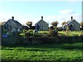
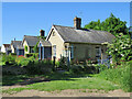
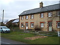
Mary Layton Cottages
Mary Layton Cottages at Little Wilbraham, Cambridgeshire.
Image: © Keith Evans
Taken: 28 Nov 2017
0.02 miles
2
Little Wilbraham: Mill Road and the backs of the almshouses
Mid March near the southern edge of the Cambridgeshire Fens.
Image: © John Sutton
Taken: 15 Mar 2017
0.02 miles
3
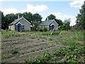
Almshouses and vegetable gardens
Two of the three Mary Layton almshouses at Little Wilbraham. For more about them, see http://www.british-history.ac.uk/report.aspx?compid=18901
Image: © John Sutton
Taken: 19 Jul 2013
0.02 miles
4
Mary Layton almshouses, Little Wilbraham
"Frederick Layton, who had emigrated as a child in 1842 and prospered at Milwaukee (U.S.A.), in 1900 bought the site of his birthplace cottage at the west end of the main street and built on it a row of three 4-roomed cottages, named after his mother Mary Layton. They were to serve as almshouses for elderly local labourers, preferably born in the parish, or their widows." http://www.british-history.ac.uk/report.aspx?compid=18901
Image: © Keith Edkins
Taken: 3 Sep 2008
0.02 miles
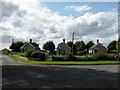
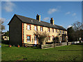
5
Little Wilbraham: the Mary Layton Cottages
These three cottages occupy a wedge of land between Mill Road and (in the foreground) Fen Road. Frederick Layton, who had emigrated in 1842 and made money in Milwaukee, bought the site of his birthplace in 1900 and built these cottages, named after his mother, as almshouses for elderly farm labourers born in the village, or their widows.
Image: © John Sutton
Taken: 9 Jun 2021
0.03 miles
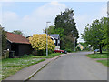
6
High Street, Little Wilbraham
Looking north west.
Image: © JThomas
Taken: 5 Mar 2016
0.05 miles
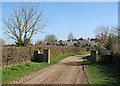
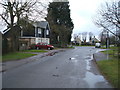
7
Little Wilbraham: the end of High Street
Beyond the tall tree the road forks: left along Mill Road to the windmill and Hawk Mill Farm, right along Fen Road to Frog End. One of the three Mary Layton Almshouses shows to the right of the tall tree.
Image: © John Sutton
Taken: 4 May 2020
0.05 miles
8
Cottages at Little Wilbraham
An attractive brick terrace on a bright January morning.
Image: © John Sutton
Taken: 18 Jan 2011
0.07 miles
10
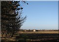
Primrose Farm to Frog End
This path starts between The Hole in the Wall and Primrose Farm and goes more directly to Frog End than the lane through the straggling west end of the village does. Stow-cum-Quy church tower, a landmark for miles around, is a pale speck on the right horizon. Image] is the view a hundred or so yards further towards Frog End.
Image: © John Sutton
Taken: 9 Dec 2011
0.16 miles