IMAGES TAKEN NEAR TO
Bartlow, CAMBRIDGE, CB21 4EN
Introduction
This page details the photographs taken nearby to CB21 4EN by members of the Geograph project.
The Geograph project started in 2005 with the aim of publishing, organising and preserving representative images for every square kilometre of Great Britain, Ireland and the Isle of Man.

There are currently over 7.5m images from over14,400 individuals and you can help contribute to the project by visiting https://www.geograph.org.uk
Image Map
Images are licensed for reuse under creativecommons.org/licenses/by-sa/2.0
Notes
- Clicking on the map will re-center to the selected point.
- The higher the marker number, the further away the image location is from the centre of the postcode.
Image Listing (41 Images Found)
Images are licensed for reuse under creativecommons.org/licenses/by-sa/2.0
Image
Details
Distance
1
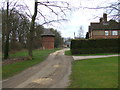
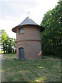
Hills Farm near Bartlow
The circular building is a former water tower. At the end of the lane is a children's nursery.
Image: © David Beresford
Taken: 21 Mar 2013
0.02 miles
3
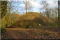
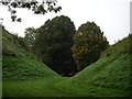
One of the Three Hills
The midmost and tallest of the tumuli (Romano-British burial mounds) hidden away within woodland on the Bartlow estate. Three of these mounds survive out of the original seven, giving the village its name ("mound among birches").
Image: © Tiger
Taken: 21 Mar 2010
0.06 miles
4
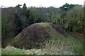
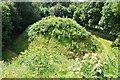
Bartlow Hills
The northernmost of the three tumuli viewed from the summit of the middle mound.
Image: © Tiger
Taken: 21 Mar 2010
0.07 miles
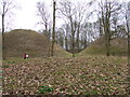
5
Romano-British cleavage
This group of Romano-British Tumuli are hidden in a wood on the Cambridge - Essex border and are only revealed to sight at the last minute, a truly remarkable monument.
Image: © Simon Leatherdale
Taken: 17 Oct 2006
0.10 miles
6

Essex & Oilseed Rape
Essex County Council put their border signs well inside the county.
Image: © Glyn Baker
Taken: 6 Apr 2021
0.10 miles
7
Bartlow Romano-British Tumuli
The largest Tumuli in the UK, they contain wooden and brick chambers filled with grave goods, some destroyed in a fire sadly. One mound was wiped out by the long gone railway. Three are well preserved.
Image: © Ashley Dace
Taken: 12 Aug 2012
0.12 miles
8
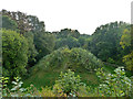
Bartlow Hills
Looking down on the mound to the south of the main mound.
Image: © David Beresford
Taken: 21 Mar 2013
0.12 miles
9
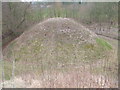
One of the Bartlow Hills
Four Romano-British tumuli survive fairly intact here, of an original seven*. Three are publicly accessible, this is one of the smaller ones, viewed from the top of by far the biggest one. The four survivors are in line roughly south to north. This is the southernmost. The other three tumuli were in a parallel row just to the west, the flattened remains of two are discernible in the public area. Needless to say, they are Ancient Monuments.
* There is a contradiction on the original number, it could be eight, which number I am inclined to favour. On the descriptive board at the site, an engraving from a 1769 publication rather clearly shows five in the main row, although the site plan on the board only shows four. The fifth, at the northern end, now shows no trace. It could have gone with the landscaping of Bartlow Park, which made a bit of a mess of the only survivor north of the railway.
Image: © Robin Webster
Taken: 3 Oct 2015
0.12 miles
10
Bartlow Hills
There were originally thought to be seven mounds on this site. They are Romano - British burial sites. The largest mound to the left is 13 metres high and 43 metres diameter.
Image: © David Beresford
Taken: 21 Mar 2013
0.13 miles