IMAGES TAKEN NEAR TO
Slaggyford, BRAMPTON, CA8 7PD
Introduction
This page details the photographs taken nearby to CA8 7PD by members of the Geograph project.
The Geograph project started in 2005 with the aim of publishing, organising and preserving representative images for every square kilometre of Great Britain, Ireland and the Isle of Man.

There are currently over 7.5m images from over14,400 individuals and you can help contribute to the project by visiting https://www.geograph.org.uk
Image Map
Images are licensed for reuse under creativecommons.org/licenses/by-sa/2.0
Notes
- Clicking on the map will re-center to the selected point.
- The higher the marker number, the further away the image location is from the centre of the postcode.
Image Listing (72 Images Found)
Images are licensed for reuse under creativecommons.org/licenses/by-sa/2.0
Image
Details
Distance
1
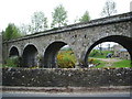
Viaduct
This viaduct carried the Haltwhistle to Alston railway over Thinhope Burn and the A689.
Image: © Alexander P Kapp
Taken: 4 May 2007
0.01 miles
2
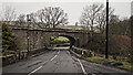
Old railway bridge over A689 at Knarsdale
Image: © Peter Moore
Taken: 1 Mar 2016
0.01 miles
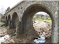
3

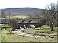
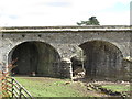
Crossing Thinhope Burn at Burnstones
The road bridge is in the foreground with the railway viaduct behind. The viaduct was built with six arches, five of which had semi-circular skew spans of 30 feet (one blind) while the sixth, over the A689 road, had an elliptical span of 39 feet, skewed in the opposite direction. Although officially known on the Alston Branch Railway as Thinhope Burn Viaduct, it was known locally as Burnstones Bridge from the nearby hamlet and farm. The asymmetric design of the 37 foot high viaduct Image was said to have been suggested by a passing gypsy or tramp just as the railway constructors were due to start work, although this seems unlikely. The railway bridge was opened in 1852.
Beyond the railway viaduct, a much older route also crossed the burn here, probably via a ford, that of the Maiden Way Roman road, now partly followed by the Pennine Way National Trail.
Image: © Andrew Curtis
Taken: 18 Feb 2015
0.01 miles
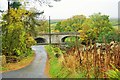
4
Burnstones Viaduct (east side)
Burnstones Viaduct carried the Haltwhistle to Alston branch line across the A689, Thinhope Burn and a sike draining the rough pastures west of Side House. For info about the branch line, see https://www.south-tynedale-railway.org.uk .
The geometry of the viaduct is unusual (possibly unique) in that the road arch is skewed one way to the line of the (former) railway , and the four arches that cross Thinhope Burn are skewed the other way - see the satellite image http://maps.google.co.uk/maps?q=Knaresdale+with+Kirkhaugh&hl=en&ll=54.88279,-2.50738&spn=0.001106,0.002438&sll=54.812167,-2.438685&sspn=0.035463,0.07802&oq=knaresdale&hnear=Knaresdale+with+Kirkhaugh,+Northumberland,+United+Kingdom&t=k&z=19 .
The builders of the bridge overcame this civil engineering problem by means of a deep blind arch between the road arch and the northernmost of the open arches that cross the burn (on the right in the photo).
So the viaduct appears to have six arches on the west side (the road arch, the blind arch and four open arches over the burn) and only five (all open arches) on the east side. For more information about the viaduct, see http://ds.dial.pipex.com/town/lane/jy40/page47.html.
See also Image, Image, Image, Image and Image
Image: © Mike Quinn
Taken: 19 Apr 2013
0.02 miles
5
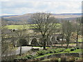
Thinhope Viaduct
Two of the elliptical skew arches of the viaduct built in 1852 for the Alston branch railway and now carrying the South Tyne Trail, viewed from the side road to Knarsdale Church and the Kirkstyle Inn. Pevsner's revisers in 1992 suggested that the engineer responsible may have been George Barclay Bruce. The left-hand arch carries the trackbed over the Thinhope Burn which flows into the South Tyne and the broader arch on the right crosses the A689 road leading from Alston to Brampton, which itself crosses the burn by an older bridge.
Image: © Tiger
Taken: 30 Oct 2015
0.02 miles
6
Burnstones Viaduct (east side) and A689 road bridge
The road bridge carrying the A689 over Thinhope Burn is nearer to the camera.
Burnstones Viaduct (behind the road bridge) carried the Haltwhistle to Alston branch line across the A689, Thinhope Burn and a sike draining the rough pastures west of Side House. For info about the branch line, see https://www.south-tynedale-railway.org.uk .
The geometry of the viaduct is unusual (possibly unique) in that the road arch is skewed one way to the line of the (former) railway , and the four arches that cross Thinhope Burn are skewed the other way - see the satellite image http://maps.google.co.uk/maps?q=Knaresdale+with+Kirkhaugh&hl=en&ll=54.88279,-2.50738&spn=0.001106,0.002438&sll=54.812167,-2.438685&sspn=0.035463,0.07802&oq=knaresdale&hnear=Knaresdale+with+Kirkhaugh,+Northumberland,+United+Kingdom&t=k&z=19 .
The builders of the bridge overcame this civil engineering problem by means of a deep blind arch (not visible in the photo above) between the road arch (the elliptical and rightmost arch in the photo) and the northernmost of the (semi-circular) open arches that cross the burn.
So the viaduct appears to have six arches on the west side (the road arch, the blind arch and four open arches over the burn) and only five (all open arches) on the east side. For more information about the viaduct, see http://ds.dial.pipex.com/town/lane/jy40/page47.html.
See also Image, Image, Image, Image and Image
Image: © Mike Quinn
Taken: 19 Apr 2013
0.02 miles
7
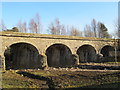
Burnstones Viaduct on the (former) Haltwhistle to Alston branch line (west side) (2)
Burnstones Viaduct crosses the A689, Thinhope Burn and a sike draining the rough pastures west of Side House. For info about the branch line, see https://www.south-tynedale-railway.org.uk .
The geometry of the viaduct is unusual (possibly unique) in that the road arch is skewed one way to the line of the (former) railway , and the four arches that cross Thinhope Burn are skewed the other way - see the satellite image http://maps.google.co.uk/maps?q=Knaresdale+with+Kirkhaugh&hl=en&ll=54.88279,-2.50738&spn=0.001106,0.002438&sll=54.812167,-2.438685&sspn=0.035463,0.07802&oq=knaresdale&hnear=Knaresdale+with+Kirkhaugh,+Northumberland,+United+Kingdom&t=k&z=19 .
The builders of the bridge overcame this civil engineering problem by means of a deep blind arch between the road arch and the northernmost of the open arches that cross the burn (on the left in the photo).
So the viaduct appears to have six arches on the west side (the road arch, the blind arch and four open arches over the burn) and only five (all open arches) on the east side. For more information about the viaduct, see http://ds.dial.pipex.com/town/lane/jy40/page47.html.
See also Image, Image, Image, Image and Image
Image: © Mike Quinn
Taken: 27 Feb 2013
0.02 miles
8
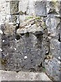
(Part of) Burnstones Viaduct (east side) and the northwest end capstone on the A689 road bridge
Burnstones Viaduct carried the Haltwhistle to Alston branch line across the A689, Thinhope Burn and a sike draining the rough pastures west of Side House. For info about the branch line, see https://www.south-tynedale-railway.org.uk .
In addition to having six arches on the west side and only five on the east, there is a further minor oddity in that the road bridge over the Thinhope Burn pre-dates the viaduct, which just clips the end of the south parapet wall - so this end capstone was cut diagonally in half http://ds.dial.pipex.com/town/lane/jy40/page47.html.
See also Image, Image, Image, Image, Image and Image
Image: © Mike Quinn
Taken: 19 Apr 2013
0.02 miles
9
Burnstones Viaduct (west side)
Burnstones Viaduct carried the Haltwhistle to Alston branch line across the A689, Thinhope Burn and a sike draining the rough pastures west of Side House. For info about the branch line, see https://www.south-tynedale-railway.org.uk .
The geometry of the viaduct is unusual (possibly unique) in that the road arch is skewed one way to the line of the (former) railway , and the four arches that cross Thinhope Burn are skewed the other way - see the satellite image http://maps.google.co.uk/maps?q=Knaresdale+with+Kirkhaugh&hl=en&ll=54.88279,-2.50738&spn=0.001106,0.002438&sll=54.812167,-2.438685&sspn=0.035463,0.07802&oq=knaresdale&hnear=Knaresdale+with+Kirkhaugh,+Northumberland,+United+Kingdom&t=k&z=19 .
The builders of the bridge overcame this civil engineering problem by means of a deep blind arch between the road arch and the northernmost of the open arches that cross the burn.
So the viaduct appears to have six arches on the west side (the road arch, the blind arch and four open arches over the burn) and only five (all open arches) on the east side. For more information about the viaduct, see http://ds.dial.pipex.com/town/lane/jy40/page47.html.
See also Image, Image, Image, Image and Image
Image: © Mike Quinn
Taken: 19 Apr 2013
0.02 miles
10
Burnstones Viaduct (west side) - blind arch
Burnstones Viaduct carried the Haltwhistle to Alston branch line across the A689, Thinhope Burn and a sike draining the rough pastures west of Side House. For info about the branch line, see https://www.south-tynedale-railway.org.uk .
The geometry of the viaduct is unusual (possibly unique) in that the road arch is skewed one way to the line of the (former) railway , and the four arches that cross Thinhope Burn are skewed the other way - see the satellite image http://maps.google.co.uk/maps?q=Knaresdale+with+Kirkhaugh&hl=en&ll=54.88279,-2.50738&spn=0.001106,0.002438&sll=54.812167,-2.438685&sspn=0.035463,0.07802&oq=knaresdale&hnear=Knaresdale+with+Kirkhaugh,+Northumberland,+United+Kingdom&t=k&z=19 .
The builders of the bridge overcame this civil engineering problem by means of a deep blind arch (on the left in the photo above) between the road arch and the northernmost of the open arches that cross the burn (on the right in the photo).
So the viaduct appears to have six arches on the west side (the road arch, the blind arch and four open arches over the burn) and only five (all open arches) on the east side. For more information about the viaduct, see http://ds.dial.pipex.com/town/lane/jy40/page47.html.
See also Image, Image, Image, Image and Image
Image: © Mike Quinn
Taken: 19 Apr 2013
0.02 miles