IMAGES TAKEN NEAR TO
Caldbeck, WIGTON, CA7 8DU
Introduction
This page details the photographs taken nearby to CA7 8DU by members of the Geograph project.
The Geograph project started in 2005 with the aim of publishing, organising and preserving representative images for every square kilometre of Great Britain, Ireland and the Isle of Man.

There are currently over 7.5m images from over14,400 individuals and you can help contribute to the project by visiting https://www.geograph.org.uk
Image Map
Images are licensed for reuse under creativecommons.org/licenses/by-sa/2.0
Notes
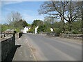
- Clicking on the map will re-center to the selected point.
- The higher the marker number, the further away the image location is from the centre of the postcode.
Image Listing (155 Images Found)
Images are licensed for reuse under creativecommons.org/licenses/by-sa/2.0
Image
Details
Distance
1
Edge of the Lake District
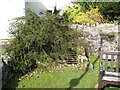
Bowten Beck flows in a culvert beneath Friar Row and marks the boundary of the Lake District National Park.
Walkers following The Cumbria Way northwards to Carlisle leave the National Park at this point (next photograph Image).
Image: © Adrian Taylor
Taken: 25 Mar 2017
0.02 miles
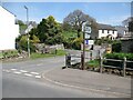
2
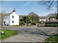
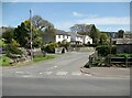
The Cumbria Way, Caldbeck
The Cumbria Way long distance path from Ulverston to Carlisle leaves Caldbeck Car Park by the entrance and approaches the B5299 road almost opposite the junction with Friar Row (next photograph Image).
Image: © Adrian Taylor
Taken: 10 May 2016
0.02 miles
4
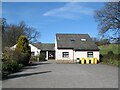
Caldbeck Surgery
Adjacent to The Cumbria Way long distance path, the purpose built doctor’s surgery is located just outside the Lake District National Park boundary and houses a rural dispensing practice.
Image: © Adrian Taylor
Taken: 25 Mar 2017
0.02 miles
5
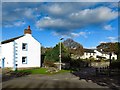
The end of Friar Row, Caldbeck
Friar Row is the route of The Cumbria Way long distance path (next photograph Image).
The Lake District National Park boundary lies just beyond the road junction where Bowten Beck passes under the road.
Image: © Adrian Taylor
Taken: 10 May 2016
0.03 miles
6
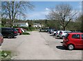
Caldbeck Car Park
The Cumbria Way long distance path from Ulverston to Carlisle passes through the car park (next photograph Image).
Image: © Adrian Taylor
Taken: 10 May 2016
0.03 miles
7
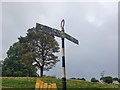
Direction Sign ? Signpost
Located on the south side of the T junction in the village by a lamp post and a grit bun in Caldbeck parish. 2 arms and annulus finial.
Milestone Society National ID: CU_NY3239B
Image: © D Phillips
Taken: Unknown
0.03 miles
8
Caldbeck car park
The small car park at Caldbeck is beside Whelpo Beck (photograph Image).
The Cumbria Way passes through the car park (next photograph Image).
Image: © Adrian Taylor
Taken: 10 Feb 2014
0.03 miles
9
Caldbeck Bridges
Caldbeck Bridges carry the B5299 road across the confluence of Gill Beck and Whelpo Beck, the united becks forming the Cald Beck, a tributary of the river Caldew. Construction of the bridges is marked by a Cumberland County Council plaque (Image).
Image: © Adrian Taylor
Taken: 10 May 2016
0.04 miles
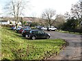
10
Caldbeck
The Cumbria Way long distance path from Ulverston to Carlisle crosses the B5299 road in the foreground and continues along Friar Row (next photograph Image).
The Lake District National Park boundary lies just beyond the road junction where Bowten Beck passes under the road.
Image: © Adrian Taylor
Taken: 10 May 2016
0.04 miles