IMAGES TAKEN NEAR TO
Irthington, CARLISLE, CA6 4ND
Introduction
This page details the photographs taken nearby to CA6 4ND by members of the Geograph project.
The Geograph project started in 2005 with the aim of publishing, organising and preserving representative images for every square kilometre of Great Britain, Ireland and the Isle of Man.

There are currently over 7.5m images from over14,400 individuals and you can help contribute to the project by visiting https://www.geograph.org.uk
Image Map
Images are licensed for reuse under creativecommons.org/licenses/by-sa/2.0
Notes
- Clicking on the map will re-center to the selected point.
- The higher the marker number, the further away the image location is from the centre of the postcode.
Image Listing (17 Images Found)
Images are licensed for reuse under creativecommons.org/licenses/by-sa/2.0
Image
Details
Distance
1
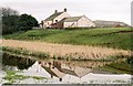
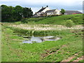
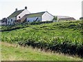
Bleatarn, looking across to Bleatarn Farm
Image: © Michael Wills
Taken: 29 Apr 2004
0.03 miles
2
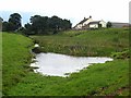
Blea Tarn
Blea Tarn occupies a section of the Vallum to the south of Hadrian's Wall. Seen from Hadrians Wall National Trail which runs 84 miles from Bowness-on-Solway to Wallsend.
http://www.nationaltrail.co.uk/hadrianswall/
Image: © Oliver Dixon
Taken: 24 Sep 2008
0.06 miles
3
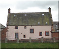
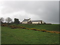
Bleatarn Farm, Near Laversdale
This handsome farmhouse stands beside the tarn which gives it its name, almost directly on the line of Hadrian's Wall
Image: © Michael Wills
Taken: 10 Apr 2004
0.07 miles
4
Bleatarn Farm
Seen from the Hadrian's Wall Path.
Image: © David Purchase
Taken: 30 May 2013
0.07 miles
5
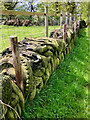
Bleatarn Farm, Near Laversdale
From the Hadrian's Wall National Trail footpath.
Image: © Andrew Curtis
Taken: 24 Aug 2003
0.08 miles
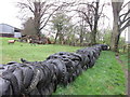
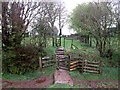
7
Second Life: Giving the Ubiquitous Old Tyres a New Purpose as a Fence
Image: © Mick Garratt
Taken: 24 Apr 2024
0.09 miles
10
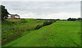
Hadrian's Wall Path passing Blea Tarn
The tarn (on the left, without much visible water) has formed in the vallum of the wall.
Image: © habiloid
Taken: 2 Aug 2016
0.10 miles