IMAGES TAKEN NEAR TO
Armathwaite, CARLISLE, CA4 9TW
Introduction
This page details the photographs taken nearby to CA4 9TW by members of the Geograph project.
The Geograph project started in 2005 with the aim of publishing, organising and preserving representative images for every square kilometre of Great Britain, Ireland and the Isle of Man.

There are currently over 7.5m images from over14,400 individuals and you can help contribute to the project by visiting https://www.geograph.org.uk
Image Map
Images are licensed for reuse under creativecommons.org/licenses/by-sa/2.0
Notes
- Clicking on the map will re-center to the selected point.
- The higher the marker number, the further away the image location is from the centre of the postcode.
Image Listing (16 Images Found)
Images are licensed for reuse under creativecommons.org/licenses/by-sa/2.0
Image
Details
Distance
2
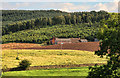
Coombs Wood, as seen from Blaze Fell
Taken from the new plantation just east of Blaze Fell quarry. Newly planted trees are visible in the foreground and the cliffs in Coombs Wood are just visible towards the centre of the image.
Image: © Jacob St John
Taken: 30 Jan 2008
0.08 miles
3
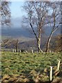
The Settle and Carlisle Railway at Baron Wood
Looking down the valley to Armathwaite
Image: © Don Burgess
Taken: 28 Jul 2007
0.10 miles
4
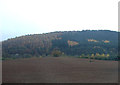
Farmland, Low Baron Wood Farm
Coombs Wood in the background.
Image: © JThomas
Taken: 3 Nov 2012
0.13 miles
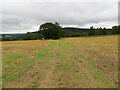
5
View towards Coombs Wood over wall on NE side of rural road SE of Coombe Eden
There is ab Ordnance Survey benchmark Image on a stone at the base of the wall
Image: © Luke Shaw
Taken: 16 Oct 2020
0.15 miles
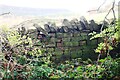
6
Gateway into Low Baronwood Farm field
Ordnance Survey documents indicate that in 1972 a benchmark levelled at 127.039m above Newlyn Datum was verified on a gatepost at this gateway which appears to have been widened
Image: © Roger Templeman
Taken: 16 Oct 2020
0.15 miles
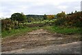
7
Grass track between harvested fields
Looking north-eastward towards Baron Wood.
Image: © Peter Wood
Taken: 10 Sep 2022
0.15 miles
8
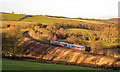
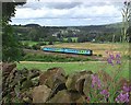
158843 on Armathwaite Curve - December 2017
Diesel unit 158843 heads the 14.04 passenger service from Carlisle to Leeds round Armathwaite Curve.
Image: © The Carlisle Kid
Taken: 15 Dec 2017
0.18 miles
9
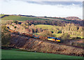
60002 on Armathwaite Curve - December 2017
Colas Rail liveried 60002 rounds Armathwaite Curve with train 6J32, the late running 12.50 loaded timber from Carlisle Yard to Chirk (Kronospan).
Image: © The Carlisle Kid
Taken: 15 Dec 2017
0.19 miles
10
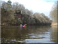
Sandstone outcrop by the River Eden
This outcrop of cross-bedded red sandstone is just downstream of the last rapid of any significance on the River Eden on the trip from Lazonby to Armathwaite. It is readily accessible from the river, of course, but can also be seen from a footpath on river right in Coombs Wood. The hillside above is penetrated by a short tunnel conducting the railway through the top of the spur.
Image: © Andy Waddington
Taken: 21 Mar 2010
0.21 miles