IMAGES TAKEN NEAR TO
Southwaite, CARLISLE, CA4 0LF
Introduction
This page details the photographs taken nearby to CA4 0LF by members of the Geograph project.
The Geograph project started in 2005 with the aim of publishing, organising and preserving representative images for every square kilometre of Great Britain, Ireland and the Isle of Man.

There are currently over 7.5m images from over14,400 individuals and you can help contribute to the project by visiting https://www.geograph.org.uk
Image Map
Images are licensed for reuse under creativecommons.org/licenses/by-sa/2.0
Notes
- Clicking on the map will re-center to the selected point.
- The higher the marker number, the further away the image location is from the centre of the postcode.
Image Listing (9 Images Found)
Images are licensed for reuse under creativecommons.org/licenses/by-sa/2.0
Image
Details
Distance
1
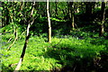
Bluebell woods by Raughtongill Bridge
An idyllic spot on the steep banks of the Raughton Gill, a tributary of the River Petteril. On this May morning cuckoos were calling and several pairs of orange tip butterflies were consorting on the fringes of the woodland. Apart from the distant hum of traffic and the occasional swish of a passing train, it was hard to believe that the site is tightly sandwiched between the M6 motorway and the West Coast Main Line railway.
Image: © Tiger
Taken: 5 May 2017
0.07 miles
2
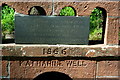
Inscription on the Katharine Well
Close-up of the inscriptions on the horse well beside Raughtongill Bridge. For an overall view see Image
Image: © Tiger
Taken: 5 May 2017
0.07 miles
3
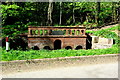
Katharine Well
"This well was built in memory of
Katharine Losh of Woodside Wreay
for the watering of horses
which used the road
Restored by members of the parish 1970
1866
KATHARINE WELL"
Katharine, who died in 1835, was the sister of Image, architect of St Mary's Church at Wreay.
For a close-up of the inscriptions see Image
Image: © Tiger
Taken: 5 May 2017
0.07 miles
4
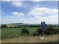
View east from the M6
Rolling farmland and woods
Image: © Eirian Evans
Taken: 9 Jul 2022
0.12 miles
5
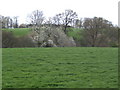
Green fields and blackthorn blossom
A view of the dairy pastures north of Mellguards. The trees are in the trench made by the Raughton Gill.
Image: © Jonathan Billinger
Taken: 17 Apr 2007
0.13 miles
6
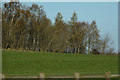
Eden : Grassy Field
A grassy field with trees seen from the M6 Motorway.
Image: © Lewis Clarke
Taken: 22 Apr 2016
0.19 miles
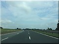
9
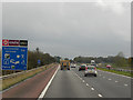
M6, North of Southwaite Services
The southbound M6, about half a mile before Southwaite Services.
Image: © David Dixon
Taken: 27 Oct 2011
0.24 miles