IMAGES TAKEN NEAR TO
Waverley Gardens, CARLISLE, CA3 9JN
Introduction
This page details the photographs taken nearby to Waverley Gardens, CA3 9JN by members of the Geograph project.
The Geograph project started in 2005 with the aim of publishing, organising and preserving representative images for every square kilometre of Great Britain, Ireland and the Isle of Man.

There are currently over 7.5m images from over14,400 individuals and you can help contribute to the project by visiting https://www.geograph.org.uk
Image Map
Images are licensed for reuse under creativecommons.org/licenses/by-sa/2.0
Notes
- Clicking on the map will re-center to the selected point.
- The higher the marker number, the further away the image location is from the centre of the postcode.
Image Listing (38 Images Found)
Images are licensed for reuse under creativecommons.org/licenses/by-sa/2.0
Image
Details
Distance
1
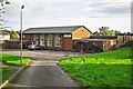
St Augustine's Parish Centre
The building predates the current RC parish church in the same grounds, which was dedicated in 1979 (photo Image ).
It was occupied for many years by St Augustine’s Social Club, which closed in 2008.
Not long after this photo was taken (August 2012), the Parish Centre was demolished. The site has been redeveloped with retirement apartments, named Waverley Court.
Image: © Rose and Trev Clough
Taken: 26 Aug 2012
0.01 miles
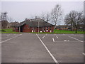
3
Semi-detached houses on NW side of Waverley Road
Ordnance Survey records indicate that a benchmark levelled at 18.459m above Newlyn Datum was verified in 1974 on the front corner, left hand face, of the nearest house (No. 24). However, an extension has been added on this face with loss of the benchmark
Image: © Luke Shaw
Taken: 15 Apr 2021
0.04 miles
4

Gosling Bridge and St Augustine's Church on SW side of A7
There is a name stone Image set into the bridge parapet
Image: © Luke Shaw
Taken: 17 Jan 2022
0.04 miles
5

The back of the west parapet of Gosling Bridge
An Ordnance Survey benchmark, http://www.bench-marks.org.uk/bm23293 , cut on the original parapet in 1844 was lost when the bridge was widened.
Image: © Roger Templeman
Taken: 18 Jul 2015
0.07 miles
6
#48 Dene Crescent
There is an OS benchmark Image on the bricks on the right hand side of the door behind a potted plant
Image: © Roger Templeman
Taken: 24 Jul 2015
0.07 miles
7

Benchmark on #48 Dene Crescent
Ordnance Survey cut mark benchmark described on the Bench Mark Database at http://www.bench-marks.org.uk/bm69415
Image: © Roger Templeman
Taken: 24 Jul 2015
0.07 miles
8

Gosling Bridge name stone on SW side of Kingstown Road
The stone indicates that the bridge was widened in 1898 and has Milestone Society National ID: CU_CL07br
Image: © Roger Templeman
Taken: 17 Jan 2022
0.07 miles
9

Inscribed stone, Gosling Bridge
For location view and information, see Image .
The inscription says 'GOSLING BRIDGE - WIDENED 1898 - C.C.C.'.
Image: © Rose and Trev Clough
Taken: 18 Oct 2017
0.07 miles
10
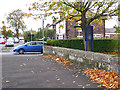
Gosling Bridge
On Scotland Road, near the junction with Waverley Road.
There's no sign of any water, but the stone wall is an old bridge parapet. Looking closely, its name can be seen in an inscription Image .
The bridge crosses Gosling Sike, a small stream which starts at Houghton and joins the River Eden near Etterby Terrace https://www.geograph.org.uk/photo/5174219 . It is culverted from Scotland Road to the outfall, flowing beneath the grounds of St Augustine's Church on the right of the parapet.
Image: © Rose and Trev Clough
Taken: 18 Oct 2017
0.07 miles