IMAGES TAKEN NEAR TO
Rigg Street, CARLISLE, CA2 5TN
Introduction
This page details the photographs taken nearby to Rigg Street, CA2 5TN by members of the Geograph project.
The Geograph project started in 2005 with the aim of publishing, organising and preserving representative images for every square kilometre of Great Britain, Ireland and the Isle of Man.

There are currently over 7.5m images from over14,400 individuals and you can help contribute to the project by visiting https://www.geograph.org.uk
Image Map
Images are licensed for reuse under creativecommons.org/licenses/by-sa/2.0
Notes
- Clicking on the map will re-center to the selected point.
- The higher the marker number, the further away the image location is from the centre of the postcode.
Image Listing (256 Images Found)
Images are licensed for reuse under creativecommons.org/licenses/by-sa/2.0
Image
Details
Distance
1
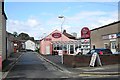
The Viceroy Bangladeshi Restaurant, August 2012
An award-winning curry house, located at this building in Rigg Street for many years. It was a casualty of the Storm Desmond floods in December 2015, and the business has since relocated across the road to Shaddongate http://www.viceroycarlisle.co.uk/ .
Image: © Rose and Trev Clough
Taken: 30 Aug 2012
0.03 miles
2
Site of "Angler's Arms Inn" - December 2016
Little seems to be known of the "Angler's Arms", which was situated on the corner of Rigg Street and Shaddongate and was closed by the State Management Scheme on 12 October 1916. Although some of the small streets off Shaddongate have vanished, this is thought to be the pub's approximate location.
Photograph is for record only - I have no connection with any business seen in this view and cannot advise on their products or services.
Image: © The Carlisle Kid
Taken: 5 Dec 2016
0.05 miles
4
Former "Pheasant" pub - December 2016 (2)
For information on this building, see: Image] .
Image: © The Carlisle Kid
Taken: 1 Dec 2016
0.06 miles
5
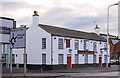
Former "Pheasant" pub - December 2016 (1)
Once three 18th century cottages combined to form a pub, the "Pheasant" opened circa 1880. Acquired by the State in August 1916, it was re-modelled internally May - October 1917 to provide meals, the Control Board being keen to provide the option of meals in comfortable surroundings. Returned to private ownership in April 1973, the pub closed in 1999 and is now a restaurant.
Photograph is for record only - I have no connection with this business and cannot advise on its products or services.
Image: © The Carlisle Kid
Taken: 1 Dec 2016
0.06 miles
6
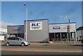
Brightly coloured buildings, John Street
Viewed from Church Street, the Curry Master takeaway shows its orange side. The modern blue, grey and yellow block is student accommodation.
Image: © Rose and Trev Clough
Taken: 7 Sep 2008
0.06 miles
7
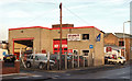
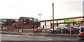
Site of Carlisle New Brewery - December 2016
A once very extensive triangular site flanked by Shaddongate, Milbourne Street and Bridge Street, the Carlisle New Brewery opened in 1774. It was acquired by the State in August 1916 and closed for brewing in 1917, although malting and bottling continued into the 1920's. It may have been renamed "The Maltings" by the Board(same address) with the site sold to the Border Dairy Co in 1973 for £31,125, with the Border Dairy Co itself sold to the Milk Marketing Board in 1974. The brewery site appears to have been cleared 1973/74 and may later have been the location of Thomas Graham's steel merchants. It has more recently been developed as largely nondescript business units. However, the architect to this fast-food outlet has at least given a passing nod to the history of the site.
Photograph is for record only - I have no connection with this business and cannot advise on its products or services.
Image: © The Carlisle Kid
Taken: 5 Dec 2016
0.07 miles
8
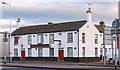
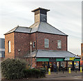
Site of "Lorne Arms" - December 2016
Situated on the corner of Broadguards and Shaddongate (just to the right in this shot, where the cars are parked), the pub dated to circa 1837 when it was known as the "Weaver's Arms". Acquired by the State in August 1916 it was closed in 1919 and demolished in 1968.
Photograph is for record only - I have no connection with any business seen in this view and cannot advise on their products or services.
Image: © The Carlisle Kid
Taken: 5 Dec 2016
0.07 miles
9
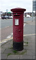
Edward VII postbox on Church Street, Carlisle
Postbox No. CA2 73.
See Image] for context.
Image: © JThomas
Taken: 28 May 2016
0.07 miles
10
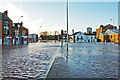
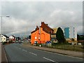
Floodwater in Caldewgate
John Street (left) merges into Church Street just past the traffic lights.
McVitie's biscuit factory is on the far right, with the Joiners Arms (white building) in front of it.
The water level had already dropped by this time, as seen by a tide mark of debris further back on the road.
Image: © Rose and Trev Clough
Taken: 6 Dec 2015
0.07 miles