IMAGES TAKEN NEAR TO
East Dale Street, CARLISLE, CA2 5JZ
Introduction
This page details the photographs taken nearby to East Dale Street, CA2 5JZ by members of the Geograph project.
The Geograph project started in 2005 with the aim of publishing, organising and preserving representative images for every square kilometre of Great Britain, Ireland and the Isle of Man.

There are currently over 7.5m images from over14,400 individuals and you can help contribute to the project by visiting https://www.geograph.org.uk
Image Map
Images are licensed for reuse under creativecommons.org/licenses/by-sa/2.0
Notes
- Clicking on the map will re-center to the selected point.
- The higher the marker number, the further away the image location is from the centre of the postcode.
Image Listing (94 Images Found)
Images are licensed for reuse under creativecommons.org/licenses/by-sa/2.0
Image
Details
Distance
1
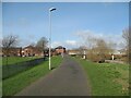
The Caldew Cycleway
The Caldew Cycleway is also the route of The Cumbria Way long distance path (next photograph Image).
The Robert Ferguson Primary School playing fields are on the left.
Image: © Adrian Taylor
Taken: 11 Mar 2019
0.05 miles
2
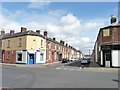
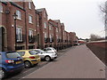
East Norfolk Street, Carlisle
Looking east across Denton Road, from Norfolk Street.
Image: © Christine Johnstone
Taken: 11 Apr 2014
0.06 miles
4
Paul Dodd Accountancy premises, #161 Denton Street
On the right end of the blue skirt around the base of the building is an OS benchmark Image
Image: © Roger Templeman
Taken: 7 Aug 2011
0.07 miles
5
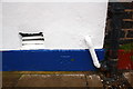
Benchmark on #161 Denton Street
The Ordnance Survey cut mark benchmark on the East Norfolk Street face of the building is described on the Bench Mark Database at http://www.bench-marks.org.uk/bm39067
Image: © Roger Templeman
Taken: 7 Aug 2011
0.07 miles
6
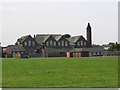
Robert Ferguson School, Denton Holme, Carlisle
Image: © Brian Norman
Taken: 9 Jul 2005
0.07 miles
7
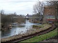
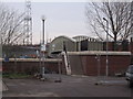
South Vale footbridge and River Caldew
Zoomed-in view from Bousteads Grassing. This is Image seen from a different angle. Opened in February 2009, it is stronger and higher than the old bridge, which was replaced as part of the Caldew flood alleviation scheme http://www.geograph.org.uk/photo/1197298 . Carlisle Cathedral can be seen in the distance.
Image: © Rose and Trev Clough
Taken: 21 Feb 2009
0.07 miles
9
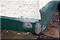
Damaged benchmark on #1 East Dale Street
The house owners appear to trying to destroy this Ordnance Survey pivot benchmark which is described on the Bench Mark Database at http://www.bench-marks.org.uk/bm39014
Image: © Roger Templeman
Taken: 7 Aug 2011
0.07 miles
10
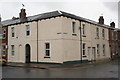
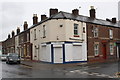
#1 East Dale Street at junction with Denton Street
The cement patching on the green skirt at the corner conceals an OS benchmark Image
Image: © Roger Templeman
Taken: 7 Aug 2011
0.07 miles