
IMAGES TAKEN NEAR TO
Lime Street, CARLISLE, CA2 5EE
Introduction
This page details the photographs taken nearby to Lime Street, CA2 5EE by members of the Geograph project.
The Geograph project started in 2005 with the aim of publishing, organising and preserving representative images for every square kilometre of Great Britain, Ireland and the Isle of Man.

There are currently over 7.5m images from over14,400 individuals and you can help contribute to the project by visiting https://www.geograph.org.uk
Image Map
Images are licensed for reuse under creativecommons.org/licenses/by-sa/2.0
Notes
- Clicking on the map will re-center to the selected point.
- The higher the marker number, the further away the image location is from the centre of the postcode.
Image Listing (599 Images Found)
Images are licensed for reuse under creativecommons.org/licenses/by-sa/2.0
Image
Details
Distance
1
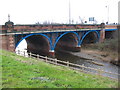
Nelson Bridge
A view looking to the southwest from the Viaduct carpark towards Nelson Bridge over the River Caldew.
Image: © Phil Williams
Taken: 15 Feb 2007
0.03 miles
2
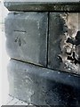
Benchmark on bridge at junction of Lorne Street and Victoria Viaduct
Ordnance Survey cut mark benchmark which is described in detail on the Bench Mark Database at http://www.bench-marks.org.uk/bm30966
Image: © Roger Templeman
Taken: 17 Jul 2010
0.03 miles
3
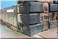
Benchmark on railway bridge, Victoria Viaduct
Ordnance Survey cut mark benchmark described on the Bench Mark Database at http://www.bench-marks.org.uk/bm30966
Image: © Roger Templeman
Taken: 7 Aug 2011
0.03 miles
4
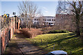
Site of "Nelson Bridge Inn" - March 2018
The "Nelson Bridge Inn" (also known as the "Nelson Bridge Hotel") dated from circa 1856 and was acquired by the State Management Scheme on 30 September 1916. It is believed to have closed in 1971 and was probably demolished circa 2005 when Nelson Bridge was widened.
Photographs indicate the pub occupied much of the bottom right in this view, with the enlarged Nelson Bridge on the left.
Image: © The Carlisle Kid
Taken: 9 Mar 2018
0.03 miles
5
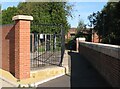
The Cumbria Way, Dentonholme
This narrow path between a sewage services compound and a flood defence wall is both the Cumbria Way and the Caldew Cycleway. Both routes turn right through the Elm Street Floodgate in the background before passing under Nelson Bridge beyond (next photograph Image).
Image: © Adrian Taylor
Taken: 28 Sep 2013
0.04 miles
6
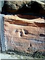
Eroding benchmark on Victoria Viaduct
Ordnance Survey cut mark benchmark which is described on the Bench Mark Database at http://www.bench-marks.org.uk/bm30952
Image: © Roger Templeman
Taken: 17 Jul 2010
0.04 miles
7
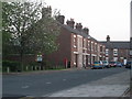
Lime Street, Carlisle
Numbers 17 to 33, as the rest have been demolished.
Image: © Stuart Irving
Taken: 6 May 2008
0.04 miles
8
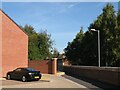
The Cumbria Way, Elm Street
The route of the Caldew Cycleway and The Cumbria Way follow the flood defence wall near the end of Elm Street, to enter the narrow path to the right of the black metal railings (next photograph Image).
This section of the Caldew Cycleway is also known as the Caldew Riverside Trail.
Image: © Adrian Taylor
Taken: 28 Sep 2013
0.04 miles
9
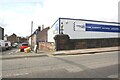
Junction of Denton Street and Lorne Street and Denton Tyres Depot
Image: © Roger Templeman
Taken: 19 Aug 2019
0.04 miles
10
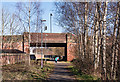
Site of former freight avoiding lines - March 2018
In the days when seven railway companies used Carlisle Citadel station, congestion was a major problem. However, the situation was eased circa 1876 by construction of a junction at Rome Street which created an avoiding line to the west of Carlisle station. Following an accident, this line closed in 1984 and is now a riverside walkway and jogging track.
Image: © The Carlisle Kid
Taken: 26 Mar 2018
0.04 miles