IMAGES TAKEN NEAR TO
Lime Street, CARLISLE, CA2 5ED
Introduction
This page details the photographs taken nearby to Lime Street, CA2 5ED by members of the Geograph project.
The Geograph project started in 2005 with the aim of publishing, organising and preserving representative images for every square kilometre of Great Britain, Ireland and the Isle of Man.

There are currently over 7.5m images from over14,400 individuals and you can help contribute to the project by visiting https://www.geograph.org.uk
Image Map
Images are licensed for reuse under creativecommons.org/licenses/by-sa/2.0
Notes
- Clicking on the map will re-center to the selected point.
- The higher the marker number, the further away the image location is from the centre of the postcode.
Image Listing (481 Images Found)
Images are licensed for reuse under creativecommons.org/licenses/by-sa/2.0
Image
Details
Distance
1
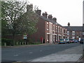
Lime Street, Carlisle
Numbers 17 to 33, as the rest have been demolished.
Image: © Stuart Irving
Taken: 6 May 2008
0.01 miles
2
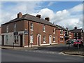
New and old homes on Thomas Street, Carlisle
Looking east from Denton Street.
Image: © Christine Johnstone
Taken: 11 Apr 2014
0.02 miles
3
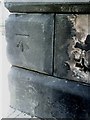
Benchmark on bridge at junction of Lorne Street and Victoria Viaduct
Ordnance Survey cut mark benchmark which is described in detail on the Bench Mark Database at http://www.bench-marks.org.uk/bm30966
Image: © Roger Templeman
Taken: 17 Jul 2010
0.04 miles
4
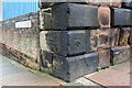
Benchmark on railway bridge, Victoria Viaduct
Ordnance Survey cut mark benchmark described on the Bench Mark Database at http://www.bench-marks.org.uk/bm30966
Image: © Roger Templeman
Taken: 7 Aug 2011
0.04 miles
5
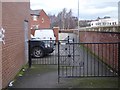
Access control on the Caldew Cycleway
Hopefully sufficient to deter motor bikes! Thomas Street is to the left. On the right is a flood wall to protect the housing from flooding by the River Caldew.
Image: © Oliver Dixon
Taken: 25 Jan 2016
0.04 miles
6
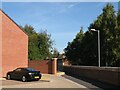
The Cumbria Way, Elm Street
The route of the Caldew Cycleway and The Cumbria Way follow the flood defence wall near the end of Elm Street, to enter the narrow path to the right of the black metal railings (next photograph Image).
This section of the Caldew Cycleway is also known as the Caldew Riverside Trail.
Image: © Adrian Taylor
Taken: 28 Sep 2013
0.05 miles
7
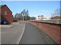
The Cumbria Way, Dentonholme
This unimaginatively designed bleak urban space is the route of the Caldew Cycleway and The Cumbria Way, alongside the high flood defence barrier which hides the River Caldew from view (next photograph Image).
Image: © Adrian Taylor
Taken: 11 Mar 2019
0.05 miles
8
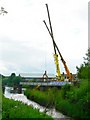
Caldew Railway Bridge - last chance to see
The bridge has stood like this since 1984, when half of it was demolished by a train crash. The incident occurred when some wagons became detached from a train and were freewheeling towards Carlisle Station. A quick-thinking signalman managed to divert them onto this line, which was opened in 1877 specifically for goods traffic, to avoid it going through the Station.
For more information on this railway see http://www.cumbria-railways.co.uk/bog_junction_carlisle.html .
Image: © Rose and Trev Clough
Taken: 19 Jun 2008
0.05 miles
9
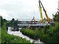
Bridge demolition in progress
Image: © Rose and Trev Clough
Taken: 19 Jun 2008
0.05 miles
10
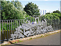
Sculptured railings beside the River Caldew
New flood walls were built along this stretch of the River Caldew in about 2008, set a few metres back from the bank. Some of the old walls were replaced with railings, which both enhance the view and allow rising water to spread over the cyclepath.
The decorative railings, created by Alan Dawson Associates of Workington, were inspired by Carlisle's railway heritage. This sculpture depicts a train crash which wrecked a nearby railway bridge in 1984 (see Image ).
The blue and red circular motif attached to the engine is part of another artwork, comprising 40 enamel plaques dotted around the city's flood defences (see Image ). It is a weather map of the British Isles dated 08/01/05 - the day that large areas of Carlisle suffered devastating floods.
Image: © Rose and Trev Clough
Taken: 1 Aug 2015
0.05 miles