IMAGES TAKEN NEAR TO
Ennerdale, CLEATOR, CA23 3AX
Introduction
This page details the photographs taken nearby to CA23 3AX by members of the Geograph project.
The Geograph project started in 2005 with the aim of publishing, organising and preserving representative images for every square kilometre of Great Britain, Ireland and the Isle of Man.

There are currently over 7.5m images from over14,400 individuals and you can help contribute to the project by visiting https://www.geograph.org.uk
Image Map
Images are licensed for reuse under creativecommons.org/licenses/by-sa/2.0
Notes
- Clicking on the map will re-center to the selected point.
- The higher the marker number, the further away the image location is from the centre of the postcode.
Image Listing (16 Images Found)
Images are licensed for reuse under creativecommons.org/licenses/by-sa/2.0
Image
Details
Distance
2
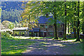
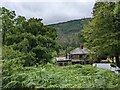
High Gillerthwaite Youth Hostel
Vehicular access up the valley of Ennerdale is banned for the public, but, paradoxically, allowed for Youth Hostellers. The YHA used to ban travel to their establishments by car.
Image: © Bob Jenkins
Taken: 1 Jan 2006
0.01 miles
4
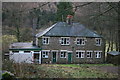
High Gillerthwaite Youth Hostel, Ennerdale
One of the more remote hostels in Lakeland which is passed on the late Alfred Wainwright’s Coast to Coast route. The nearest public access point by car is the Bowness Knott Car Park which is two and a half miles away. It is one of two youth hostels in the Ennerdale valley. The Black Sail Hut, further up the valley, is even more remote.
Image: © Peter S
Taken: 17 Jun 2013
0.02 miles
6
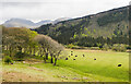
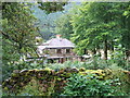
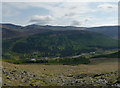
Trees and cattle near to High Gillerthwaite
High Gillerthwaite, Ennerdale Youth Hostel, is just out of view, to the left of the image.
Pillar, Scoat Fell and Steeple are peaks along the skyline.
Image: © Trevor Littlewood
Taken: 28 Apr 2021
0.04 miles
7
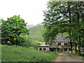
In Ennerdale
Near High Gillerthwaite
Image: © Michael Graham
Taken: 26 Mar 2017
0.04 miles
8
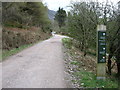
The track up Ennerdale
Only authorised vehicles are allowed beyond the car park in Image The sign on the right seems happy to mix metric and Imperial units!
Image: © David Purchase
Taken: 8 Apr 2014
0.09 miles
9
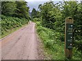
Lots of directions on the trackside post
Image: © David Medcalf
Taken: 6 Jul 2022
0.09 miles
10
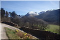
Ennerdale Forest and the River Liza
Ennerdale Forest and the River Liza from the ascent of Red Pike. The ridge from
Pillar through Stoat Fell and Haycock to Ennerdale Fell lies beyond.
Image: © Gareth Jones
Taken: 19 May 2012
0.14 miles