IMAGES TAKEN NEAR TO
Church Brough, KIRKBY STEPHEN, CA17 4EN
Introduction
This page details the photographs taken nearby to CA17 4EN by members of the Geograph project.
The Geograph project started in 2005 with the aim of publishing, organising and preserving representative images for every square kilometre of Great Britain, Ireland and the Isle of Man.

There are currently over 7.5m images from over14,400 individuals and you can help contribute to the project by visiting https://www.geograph.org.uk
Image Map
Images are licensed for reuse under creativecommons.org/licenses/by-sa/2.0
Notes
- Clicking on the map will re-center to the selected point.
- The higher the marker number, the further away the image location is from the centre of the postcode.
Image Listing (213 Images Found)
Images are licensed for reuse under creativecommons.org/licenses/by-sa/2.0
Image
Details
Distance
1
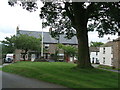
Church Brough
From the bridge over Augill Beck looking towards Bridge House and Brough Castle.
Image: © David Rogers
Taken: 7 Apr 2009
0.01 miles
2
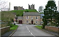
![Brough houses [3]](https://s3.geograph.org.uk/geophotos/07/30/23/7302327_cf220403_120x120.jpg)
Brough houses [3]
Bridge House, Church Brough, was built in the late 18th or early 19th century. Constructed of squared, coursed rubble stone with freestone dressings under a slate roof. Listed, grade II, with details at: https://historicengland.org.uk/listing/the-list/list-entry/1326985
Brough is a village in the Eden district of Cumbria, some 21 miles northeast of Kendal and about 30 miles west of Darlington. The village is on the A66 road, a key route across the Pennine Mountains via the Stainmore Pass. Brough is on the site of the Roman fort of Verterae and has the ruins of a Norman castle. The village has historically been divided into Market Brough, to the north, and Church Brough, to the south.
Image: © Michael Dibb
Taken: 20 Jun 2022
0.01 miles
3
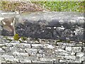
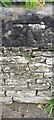
Ordnance Survey Cut Mark
This OS cut mark can be found on the east parapet of Church Brough Bridge. It marks a point 173.372m above mean sea level.
Image: © Adrian Dust
Taken: 28 Oct 2023
0.01 miles
4
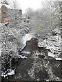
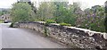
Argill Beck Brough
Looking from footbridge. Fish ladder/weir covered by flow.
Image: © colin
Taken: 28 Nov 2021
0.02 miles
5
Benchmark on east parapet of Church Brough Bridge
Ordnance Survey cut mark benchmark levelled at 173.372m above Newlyn Datum in 1974. The mark was previously levelled at 568.652 feet above Liverpool Datum during the 1844 Penrith to Darlington 1GL Survey. The surveyor's description was 'Branch Levelling from No. 75. Church Brough Bridge. Mark on East battlement ; 3.26 ft. above surface'
Image: © Roger Templeman
Taken: 20 May 2022
0.02 miles
6
![Brough features [2]](https://s2.geograph.org.uk/geophotos/07/30/23/7302330_d41cd845_120x120.jpg)
Brough features [2]
A footbridge has been erected alongside the road bridge in Church Brough, carrying pedestrians over Augill Beck. The road is much less used since 1977 when this section of the A685 was bypassed.
Brough is a village in the Eden district of Cumbria, some 21 miles northeast of Kendal and about 30 miles west of Darlington. The village is on the A66 road, a key route across the Pennine Mountains via the Stainmore Pass. Brough is on the site of the Roman fort of Verterae and has the ruins of a Norman castle. The village has historically been divided into Market Brough, to the north, and Church Brough, to the south.
Image: © Michael Dibb
Taken: 20 Jun 2022
0.02 miles
7
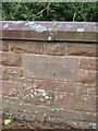
Eastern parapet of Church Brough Bridge
There is an Ordnance Survey benchmark Image on the bridge coping stone where vegetation overhangs
Image: © Roger Templeman
Taken: 20 May 2022
0.03 miles
8
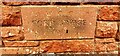
Name plaque on north parapet of Ford Bridge
The plaque has Milestone Society National ID: WE_BROUGH02br
Image: © Roger Templeman
Taken: 20 May 2022
0.04 miles
9
Old Boundary Marker
Bridge Marker set in the northern bridge parapet of Ford Bridge, Augill Beck in Church Brough. Brough parish. Inscribed W C C / FORD BRIDGE / 1971.
Milestone Society National ID: WE_BROUGH02br
Image: © Mike Rayner
Taken: 6 Nov 2020
0.04 miles