IMAGES TAKEN NEAR TO
Battlebarrow, APPLEBY-IN-WESTMORLAND, CA16 6XU
Introduction
This page details the photographs taken nearby to Battlebarrow, CA16 6XU by members of the Geograph project.
The Geograph project started in 2005 with the aim of publishing, organising and preserving representative images for every square kilometre of Great Britain, Ireland and the Isle of Man.

There are currently over 7.5m images from over14,400 individuals and you can help contribute to the project by visiting https://www.geograph.org.uk
Image Map
Images are licensed for reuse under creativecommons.org/licenses/by-sa/2.0
Notes
- Clicking on the map will re-center to the selected point.
- The higher the marker number, the further away the image location is from the centre of the postcode.
Image Listing (23 Images Found)
Images are licensed for reuse under creativecommons.org/licenses/by-sa/2.0
Image
Details
Distance
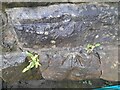
4
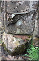
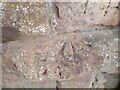
Remains of benchmark on Bridge SAC 239
The Ordnance Survey projecting bracket benchmark is described on the Bench Mark Database at http://www.bench-marks.org.uk/bm25206. There is a wider view of the location at Image - the bracket was mounted to the right of the telephone kiosk.
Image: © Roger Templeman
Taken: 7 May 2015
0.07 miles
5
Ordnance Survey Pivot
This OS pivot can be found on the SE side of the railway bridge.
Image: © Adrian Dust
Taken: 27 Oct 2023
0.07 miles
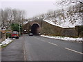
6
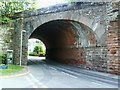
Bridge SAC239
View through bridge taking Settle-Carlisle Railway over Long Marton Road with houses of Belgravia visible.
Image: © Roger Templeman
Taken: 26 Jun 2010
0.07 miles
7
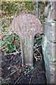
Old Boundary Marker
Railway Boundary Marker on the northeast side of the B6542 Battlebarrow at the end of a low stone wall. APPLEBY IN WESTMORLAND parish. M R (Midland Railway) in raised lettering.
Milestone Society National ID: WE_APPL02em
Image: © R Templeman
Taken: 19 Feb 2019
0.07 miles
8
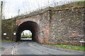
Railway Bridge SAC 277m 1220yds, Long Marton Road
The bridge carries the Settle-Carlisle Railway, here 277+ miles via the Midland Railway route to London. There is an OS benchmark Image on the bridge wall left of the arch.
Image: © Roger Templeman
Taken: 7 May 2015
0.08 miles
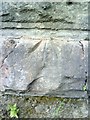
9
Ordnance Survey Pivot
This OS pivot can be found on the north face of the railway bridge.
Image: © Adrian Dust
Taken: 27 Oct 2023
0.09 miles
10
Belgravia, benchmark
This appears to be a pivot benchmark on railway bridge at junction of Belgravia and Long Marton Road. See Bench Mark Database record http://www.bench-marks.org.uk/bm34738 for more details.
Image: © Roger Templeman
Taken: 26 Jun 2010
0.09 miles