IMAGES TAKEN NEAR TO
Copperas Hill, WORKINGTON, CA14 5RX
Introduction
This page details the photographs taken nearby to Copperas Hill, CA14 5RX by members of the Geograph project.
The Geograph project started in 2005 with the aim of publishing, organising and preserving representative images for every square kilometre of Great Britain, Ireland and the Isle of Man.

There are currently over 7.5m images from over14,400 individuals and you can help contribute to the project by visiting https://www.geograph.org.uk
Image Map
Images are licensed for reuse under creativecommons.org/licenses/by-sa/2.0
Notes
- Clicking on the map will re-center to the selected point.
- The higher the marker number, the further away the image location is from the centre of the postcode.
Image Listing (5 Images Found)
Images are licensed for reuse under creativecommons.org/licenses/by-sa/2.0
Image
Details
Distance
1
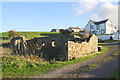
Ruined barn and houses at Harrington Parks beside former mineral railway trackbed
Image: © Roger Templeman
Taken: 18 Oct 2018
0.07 miles
2
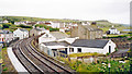
Site of former Copperas Hill station
View southward from Harrington station, to Copperas Hill on the ex-Cleator & Workington Junction light railway branch from Harrington Junction to Lowca - as steep as 1-in-17, closed to passengers 1/2/29, to freight much later. Nothing whatever of this Lowca branch is in fact visible, but merely the ex-LNWR (Carlisle) - Maryport - Workington - Whitehaven (Coast) line going south from Harrington station, below the hills showing scars of the former industrial landscape.
Image: © Ben Brooksbank
Taken: 2 Jul 2002
0.08 miles
3
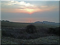
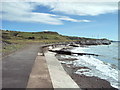
Moss Bay from path on Copperas Hill
View over Moss Bay and Bellaport Marina from the bridleway on Copperas Hill.
Image: © Robert Matin
Taken: 5 Mar 2013
0.19 miles