IMAGES TAKEN NEAR TO
WORKINGTON, CA14 1JL
Introduction
This page details the photographs taken nearby to CA14 1JL by members of the Geograph project.
The Geograph project started in 2005 with the aim of publishing, organising and preserving representative images for every square kilometre of Great Britain, Ireland and the Isle of Man.

There are currently over 7.5m images from over14,400 individuals and you can help contribute to the project by visiting https://www.geograph.org.uk
Image Map
Images are licensed for reuse under creativecommons.org/licenses/by-sa/2.0
Notes
- Clicking on the map will re-center to the selected point.
- The higher the marker number, the further away the image location is from the centre of the postcode.
Image Listing (21 Images Found)
Images are licensed for reuse under creativecommons.org/licenses/by-sa/2.0
Image
Details
Distance
1
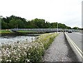
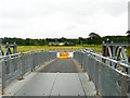
Barker Crossing, River Derwent, Workington
In November 2009 severe flooding of the River Derwent brought down or damaged all four road and pedestrian bridges in Workington. The railway bridge survived, but travelling between the north and south sides of the town by road involved a 14 mile detour, with long delays in the rush hour.
The Army were requested to build this temporary footbridge, and worked round the clock in difficult conditions to complete it. The bridge was opened 18 days after the floods hit.
It is named in memory of Police Constable Bill Barker, who was swept to his death when the Northside Bridge http://www.geograph.org.uk/photo/571476 collapsed under him as he was directing motorists away from it.
For more information see Wikipedia article http://en.wikipedia.org/wiki/Barker_Crossing .
Other photos with additional descriptions on Geograph : http://www.geograph.org.uk/photo/2096743 http://www.geograph.org.uk/photo/2096817 http://www.geograph.org.uk/photo/2096835 .
Image: © Rose and Trev Clough
Taken: 28 Aug 2010
0.04 miles
2
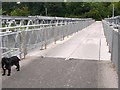
Barker Crossing, the deck
For background information, see Image . This temporary footbridge across the River Derwent is 52m long and weighs 110 tonnes. It is a Mabey Compact 200 bridge http://www.mabeybridge.co.uk/compact-bridging.asp built from prefabricated components.
It was opened on the morning of 7 December 2009. First across were children, who had been putting up with long bus journeys when floods destroyed their usual routes to school.
Image: © Rose and Trev Clough
Taken: 28 Aug 2010
0.04 miles
3
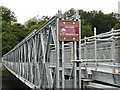
Sign on Barker Crossing
For background information see Image . The sign says "BARKER CROSSING - BUILT BY 3 ARMD ENGR SQN DEC 2009"
Up to 200 soldiers from the Regular and Territorial Army were involved in the planning, transport and erection of this footbridge, which is of a type used by the British Army in conflict zones such as Iraq and Afghanistan.
Image: © Rose and Trev Clough
Taken: 28 Aug 2010
0.05 miles
4
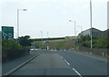
South side of Barker Crossing
For background information see Image . This is on Mill Field - Workington Hall Mill can be seen in the distance. Bus services operated between here and the town centre until a new temporary road bridge reconnected the north and south sides of Workington in April 2010. The area of hardstanding was for the buses to turn - private vehicles were not allowed here or on the access road.
Image: © Rose and Trev Clough
Taken: 28 Aug 2010
0.06 miles
5
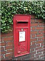
Post box, Calva Brow
A George VI wall box in an ivy topped garden wall on Calva Brow, Workington.
Image: © Graham Robson
Taken: 6 Nov 2014
0.08 miles
6
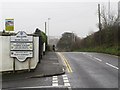
Welcome to Workington
The sign welcoming those who pass it into Workington. Proud winners of Cumbria in Bloom on several occasions. The sign doesn't indicate Workington's fate in the competition in the years since 2005, I couldn't help thinking whether they had simply ran out of space on the sign or if their fortunes in the competition had waned since.
Image: © Graham Robson
Taken: 6 Nov 2014
0.10 miles
7
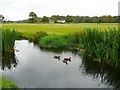
Ducks on the Mill Stream
The field here is part of a large area of parkland gifted to the people of Workington by the Curwen family who once lived in Workington Hall http://www.geograph.org.uk/photo/571432 . Its official title is Curwen Park http://www.allerdale.gov.uk/environment-and-planning/parks-and-open-spaces/parks-and-open-spaces---genera/curwen-park.aspx but it is commonly called Hall Park.
The stream flows from the River Derwent past Workington Hall Mill, seen in the distance.
Image: © Rose and Trev Clough
Taken: 28 Aug 2010
0.13 miles
8
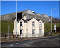
Tollhouse by the A596, Calva Brow, Workington
Tollhouse by the A596, in parish of Workington (Allerdale District), Toll Bar House, Calva Brow.
Demolished in 2015.
To be surveyed
Milestone Society National ID: CB.WOR
Image: © Milestone Society
Taken: Unknown
0.14 miles
9
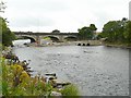
Workington (Calva) Bridge under repair
The bridge was so badly damaged when the River Derwent flooded in November 2009, it was thought collapse or demolition was inevitable. Part of the central pier was washed away, causing the deck to drop by about 1ft and twist out of shape http://en.wikipedia.org/wiki/File:Workington_%27Calva%27_Bridge._Collapsed_Navvies_visible_(photo-_Andy_V_Byers).JPG . Engineers decided it could be repaired, but it would be a delicate operation.
This photo shows an access causeway constructed on the upstream side of the bridge, with pipes incorporated to maintain river flow.
The bridge was built in 1841 and is a Grade II listed structure http://www.imagesofengland.org.uk/details/default.aspx?id=72281 . Named Workington Bridge, when it was the main road bridge into the town, now usually called Calva Bridge due to its location.
Image: © Rose and Trev Clough
Taken: 28 Aug 2010
0.14 miles