Workington (Calva) Bridge under repair
Introduction
The photograph on this page of Workington (Calva) Bridge under repair by Rose and Trev Clough as part of the Geograph project.
The Geograph project started in 2005 with the aim of publishing, organising and preserving representative images for every square kilometre of Great Britain, Ireland and the Isle of Man.

There are currently over 7.5m images from over 14,400 individuals and you can help contribute to the project by visiting https://www.geograph.org.uk
Workington (Calva) Bridge under repair
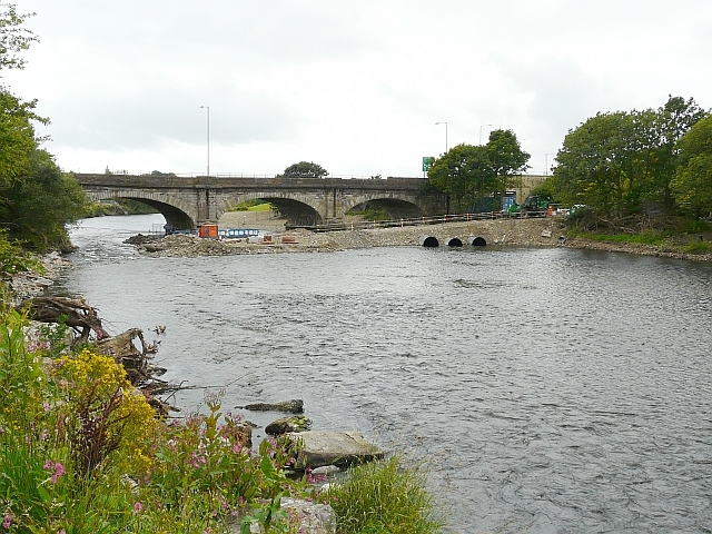
Image: © Rose and Trev Clough Taken: 28 Aug 2010
The bridge was so badly damaged when the River Derwent flooded in November 2009, it was thought collapse or demolition was inevitable. Part of the central pier was washed away, causing the deck to drop by about 1ft and twist out of shape http://en.wikipedia.org/wiki/File:Workington_%27Calva%27_Bridge._Collapsed_Navvies_visible_(photo-_Andy_V_Byers).JPG . Engineers decided it could be repaired, but it would be a delicate operation. This photo shows an access causeway constructed on the upstream side of the bridge, with pipes incorporated to maintain river flow. The bridge was built in 1841 and is a Grade II listed structure http://www.imagesofengland.org.uk/details/default.aspx?id=72281 . Named Workington Bridge, when it was the main road bridge into the town, now usually called Calva Bridge due to its location.
Images are licensed for reuse under creativecommons.org/licenses/by-sa/2.0
Image Location
Latitude
54.647031
Longitude
-3.539139