IMAGES TAKEN NEAR TO
Loweswater, COCKERMOUTH, CA13 0SU
Introduction
This page details the photographs taken nearby to CA13 0SU by members of the Geograph project.
The Geograph project started in 2005 with the aim of publishing, organising and preserving representative images for every square kilometre of Great Britain, Ireland and the Isle of Man.

There are currently over 7.5m images from over14,400 individuals and you can help contribute to the project by visiting https://www.geograph.org.uk
Image Map
Images are licensed for reuse under creativecommons.org/licenses/by-sa/2.0
Notes
- Clicking on the map will re-center to the selected point.
- The higher the marker number, the further away the image location is from the centre of the postcode.
Image Listing (14 Images Found)
Images are licensed for reuse under creativecommons.org/licenses/by-sa/2.0
Image
Details
Distance
1
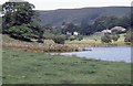
Waterend
Seen from the shore of Loweswater.
Image: © Richard Sutcliffe
Taken: Unknown
0.07 miles
2
Grange Lane
Grange Lane coming out to the road at Waterend
Image: © Shaun Ferguson
Taken: 13 Jul 2012
0.09 miles
3
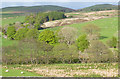
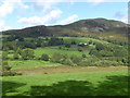
Near Graythwaite
The line of trees marks an unnamed beck.
Image: © Anne Burgess
Taken: 24 May 2013
0.14 miles
4
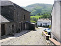
Hudson Place, Loweswater
I wonder if the Royal College of Arms know about the coat-of-arms over the door of this yeoman's farmhouse! A quick websearch revealed that the yeoman in 1910 was John Wilkinson. This is at NY115223.
Image: © Humphrey Bolton
Taken: 4 Jan 2004
0.14 miles
5
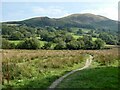
Footpath at Waterend
Across marshy ground at the head of Loweswater. Darling Fell Image across the valley.
Image: © Oliver Dixon
Taken: 5 Sep 2021
0.17 miles
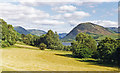
6
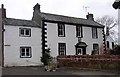
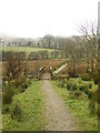
View from the path near Hudson Place
The path around the southern shore of Loweswater passes through Hudson Place to reach the road at Waterend. The fell in the background is Darling Fell.
Image: © Marathon
Taken: 25 Aug 2018
0.18 miles
8
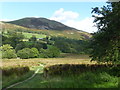
Path to Waterend
The path around the southern shore of Loweswater passes through Hudson Place to reach the road ahead at Waterend. The fell in the background is Darling Fell.
Image: © Marathon
Taken: 25 Aug 2018
0.19 miles
9
Loweswater from Waterend
View SE: nearest on the right are the Loweswater Fells (Mellbreak (1,668 ft.) prominent), Pillar (2,927 ft.) is in the distance; on the left are Brackenthwaite (2,317 ft.) and Grasmoor (2,742 ft.).
Image: © Ben Brooksbank
Taken: 8 Jul 1986
0.19 miles
10
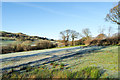
Frosted field above Loweswater
The field is close to the boundary of the Lake District National Park in the area named on OS maps as Waterend. Being on a south facing slope of a day of unbroken sunshine, the frost didn't linger for long, but would persist all day in places where there was continual shade.
Image: © Trevor Littlewood
Taken: 1 Dec 2019
0.20 miles