IMAGES TAKEN NEAR TO
Riverside Terrace, COCKERMOUTH, CA13 0JE
Introduction
This page details the photographs taken nearby to Riverside Terrace, CA13 0JE by members of the Geograph project.
The Geograph project started in 2005 with the aim of publishing, organising and preserving representative images for every square kilometre of Great Britain, Ireland and the Isle of Man.

There are currently over 7.5m images from over14,400 individuals and you can help contribute to the project by visiting https://www.geograph.org.uk
Image Map
Images are licensed for reuse under creativecommons.org/licenses/by-sa/2.0
Notes
- Clicking on the map will re-center to the selected point.
- The higher the marker number, the further away the image location is from the centre of the postcode.
Image Listing (348 Images Found)
Images are licensed for reuse under creativecommons.org/licenses/by-sa/2.0
Image
Details
Distance
1
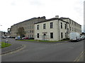
Former Derwent Mill, Cockermouth
Linen Mill of the Harris company from 1834 to the early 1930s. Also produced silk and embroidery thread. Milers shoe factory was evacuated here from Great Yarmouth in 1941 and remained until 1990. Now converted to offices and flats.
Image: © Chris Allen
Taken: 20 Sep 2017
0.04 miles
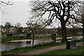
2
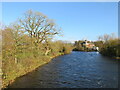
River Derwent, Cockermouth
The River Derwent flowing through Cockermouth in Cumbria. The building in the centre-right of the image is a brewery, which stands at the confluence of the Cocker (to the right) and Derwent (to the left). It is the River Cocker which gives its name to the town/
Image: © Malc McDonald
Taken: 25 Nov 2022
0.04 miles
3
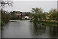
River Derwent
Looking up river from Millers Bridge, towards the Jennings brewery, which stands at the confluence of the Rivers Derwent and Cocker.
Image: © Peter Trimming
Taken: 6 May 2016
0.04 miles
5
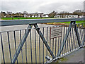
Plaque on Millers Bridge
For a different view of the location, see Image . About half of the bridge collapsed during severe flooding of the River Derwent in November 2009. It was repaired, extended and reinstated - the plaque records the reopening of the bridge by The Princess Royal in July 2010.
We guess the bridge gets its name from Millers shoe factory, which was a major employer for about 50 years, closing in the early 1990s. It was on the north side of the river at Image . The 19th century mill was built by the Harris family - on official maps this bridge is called Harris Bridge.
Image: © Rose and Trev Clough
Taken: 21 Dec 2013
0.05 miles
6
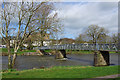
Harris Bridge, Cockermouth
Also known as Millers Bridge, this footbridge spans the River Derwent. It was rebuilt after the 2009 floods. The abutment on the far side (right bank) collapsed causing the far end of the span to drop into the river. (See Image & https://www.visitcumbria.com/cockermouth-floods/#gallery/34d7ddbca68be69d50f987eaca91a83e/2980 )
Image: © Ian Taylor
Taken: 12 Mar 2019
0.05 miles
7
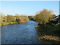
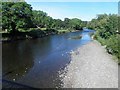
River Derwent, Cockermouth
The River Derwent flowing through Cockermouth in Cumbria.
Image: © Malc McDonald
Taken: 25 Nov 2022
0.05 miles

9
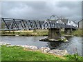
Cockermouth, Millers Bridge
Millers Bridge, as it is known in Cockermouth (official maps refer to it as Harris Bridge), was reopened in 2010 by HRH the Princess Royal after it had suffered severe damage in the 2009 floods and a section of it collapsed into the River Derwent. Part of the steel bridge had to be rebuilt to fit the new shape of the river banks, which were heavily eroded during the floods and have now been fortified.
See Image
Image: © David Dixon
Taken: 12 Apr 2014
0.05 miles
10
Cockermouth
Looking across the River Derwent, towards Millers Bridge.
Image: © Peter Trimming
Taken: 6 May 2016
0.05 miles