IMAGES TAKEN NEAR TO
Stuart Terrace, KESWICK, CA12 4RY
Introduction
This page details the photographs taken nearby to Stuart Terrace, CA12 4RY by members of the Geograph project.
The Geograph project started in 2005 with the aim of publishing, organising and preserving representative images for every square kilometre of Great Britain, Ireland and the Isle of Man.

There are currently over 7.5m images from over14,400 individuals and you can help contribute to the project by visiting https://www.geograph.org.uk
Image Map
Images are licensed for reuse under creativecommons.org/licenses/by-sa/2.0
Notes
- Clicking on the map will re-center to the selected point.
- The higher the marker number, the further away the image location is from the centre of the postcode.
Image Listing (98 Images Found)
Images are licensed for reuse under creativecommons.org/licenses/by-sa/2.0
Image
Details
Distance
1
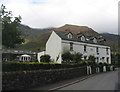
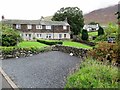
Stuart Villas, Threlkeld
The short terrace of houses has a date stone of 1902. Gategill Fell in the background.
Image: © E Gammie
Taken: 22 Aug 2018
0.01 miles
2
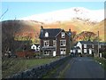
Threlkeld and Knowe Crags
Threlkeld is dominated by Blencathra (of which Knowe Crags form a westerly spur), one of the most imposing mountains in the Lake District.
Image: © Oliver Dixon
Taken: 10 Dec 2007
0.03 miles
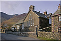
3
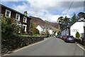
Threlkeld Village Hall
This road was formerly the A66 before a realignment of the road was constructed providing a bypass to the south of the village. The village hall is on the right.
Image: © DS Pugh
Taken: 31 Mar 2024
0.03 miles
4
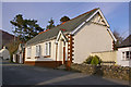
Threlkeld Public Room
Built in 1901 and serves as the village hall.
Image: © Ian Capper
Taken: 8 Apr 2008
0.03 miles
6
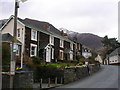
Overlooked by Blencathra
Cottages in Threlkeld
Image: © John H Darch
Taken: 27 Mar 2009
0.04 miles
7
Threlkeld C of E Primary School
Until 1776 village children were taught in the chancel of the church (see Image). However, when this was demolished, a school house was built in Blease Road for boys only (see Image). In 1842 an upper floor was added for girls. In 1849 the school moved across the road to the new buildings shown here.
Image: © Ian Capper
Taken: 8 Apr 2008
0.05 miles
8
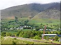
Threlkeld village seen from the quarry
Zoomed-in view from the Threlkeld Quarry and Mining Museum http://www.threlkeldquarry.co.uk/index.htm .
The fells are Blease (left) and Gategill.
Image: © Rose and Trev Clough
Taken: 8 May 2011
0.05 miles
9
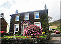
House in Threlkeld
With rhododendron in full bloom.
Image: © Helen Wilkinson
Taken: 30 Apr 2009
0.05 miles
10
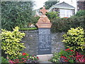
Threlkeld war memorial
The memorial to the men of the locality who fell in WWI and WWII. The inscription reads:
"IN HONOUR OF THE
MEN OF THRELKELD
DISTRICT WHO DIED
IN TWO WORLD WARS
1914 - 1918
TP Greenwood Sgt. T Stuart Sgt.
F Atkinson Pte. E Bell Pte.
WE Crooks Pte. H Earl Pte.
W Hind Pte. B Stuart Pte.
C Stuart Pte. JB Stuart Pte.
R Todhunter Pte. F Wilson Pte.
TA Watson Pte.
1939-1945
GJ Purcell Maj. JB Hindmoor Pte.
A Tangye Pte. TW Taylor Pte.
T Wren Pte.
Their name liveth for evermore."
Those who died in WWI are also listed on a plaque in Image], together with their regimental details.
Image: © E Gammie
Taken: 21 Aug 2018
0.06 miles