IMAGES TAKEN NEAR TO
King Street, CARLISLE, CA1 1SR
Introduction
This page details the photographs taken nearby to King Street, CA1 1SR by members of the Geograph project.
The Geograph project started in 2005 with the aim of publishing, organising and preserving representative images for every square kilometre of Great Britain, Ireland and the Isle of Man.

There are currently over 7.5m images from over14,400 individuals and you can help contribute to the project by visiting https://www.geograph.org.uk
Image Map
Images are licensed for reuse under creativecommons.org/licenses/by-sa/2.0
Notes
- Clicking on the map will re-center to the selected point.
- The higher the marker number, the further away the image location is from the centre of the postcode.
Image Listing (647 Images Found)
Images are licensed for reuse under creativecommons.org/licenses/by-sa/2.0
Image
Details
Distance
1
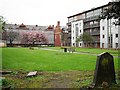
Park on site of former church
Christ Church once stood here, the fairly substantial building had a tower with a spire, which appears in this photo c.1910 http://photos1.blogger.com/blogger/5650/2232/1600/c6.18.jpg (from "Carlisle Postcards" blog http://carlislepostcards.blogspot.com/ ). The church was consecrated in 1830 and demolished in 1953. There are still a few headstones around the sides of the park. Another view from Botchergate here Image .
The block of flats on the right is called The Picture House, built on the site of the disused Palace Cinema which was destroyed by fire in 2004.
Image: © Rose and Trev Clough
Taken: 23 Apr 2011
0.02 miles
2
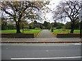
The site of Christ Church, Carlisle
These public gardens are laid out on the site of Christ Church, just off Botchergate, Carlisle. Christ Church was completed in 1830 as a Chapel of Ease for St Cuthbert's in the town centre. I don't know when it was demolished.
Image: © John S Turner
Taken: 5 Nov 2004
0.03 miles
3
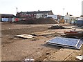
William Street Car Park, closed for redevelopment
Preparations underway for construction of a new office building, to face onto Botchergate. The work was completed in autumn 2016 - see Image .
Archaeological excavations on the site revealed a Roman cemetery, from which many artefacts were recovered - see Cumberland News http://www.cumberlandnews.co.uk/news/Roman-artefacts-found-on-site-of-new-council-HQ-in-Carlisle-6efa639e-9a48-4fb2-9fa2-04c6d254b13c-ds .
Image: © Rose and Trev Clough
Taken: 5 Feb 2015
0.03 miles
4
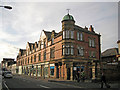
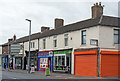
Building in Botchergate
This large building was almost certainly built as a single shop, though is currently in use by several separate businesses.
Image: © Richard Dorrell
Taken: 25 Jul 2011
0.03 miles
5
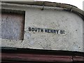
South Henry Street Sign
Despite being embedded in the pebbledash coating on the wall, this old cast street sign for South Henry Street has been carefully painted to highlight the name. The sign is on the wall where South Henry Street joins the main road, Botchergate, on the right. The properties in this street are very old and many are showing signs of decay. See also Image
Image: © John S Turner
Taken: 5 Nov 2004
0.04 miles
6

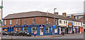
Ready for redevelopment?
These boarded up buildings stand on the corner of South Henry Street in Botchergate, Carlisle.
Image: © Richard Dorrell
Taken: 25 Jul 2011
0.05 miles
7

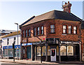
Nos 107 to 117 Botchergate, May 2013
This row of buildings was demolished in 2015. The site has been redeveloped with offices for Cumbria County Council, which opened in autumn 2016 - see Image .
The block was constructed in the early to mid 19th century. For most of its existence there were shop or business premises fronting onto the street, with residential accommodation upstairs and to the rear. A series of photos taken along Botchergate in 1961 (available at Cumbria Image Bank http://cumbriaimagebank.org.uk/ - search for Jackson TC) shows five different units on this stretch. In the 2013 view three of them have been combined into one office (with shutters), most recently used by the NHS.
Image: © Rose and Trev Clough
Taken: 19 May 2013
0.05 miles
8
Hebron Evangelical Church and Crown Street Baguettes - April 2018
Junction of Crown Street and Botchergate.
Photograph is for record only – I have no connection with any business or organisation seen in this view and cannot advise on their products or services.
Image: © The Carlisle Kid
Taken: 5 Apr 2018
0.05 miles
9
Lower Botchergate, Carlisle - June 2017 (1)
The south-west side of Botchergate from Princess Street to King Street. Built between 1828 and 1836, this row once contained the "Queen Adelaide" pub, which is thought to have been the second building from the left - see: Image] .
Photograph is for record only - I have no connection with any business seen in this view and cannot advise on their products or services.
Image: © The Carlisle Kid
Taken: 14 Jun 2017
0.05 miles
10
Lower Botchergate, Carlisle - June 2017 (2)
For information on these buildings, see: Image] .
Image: © The Carlisle Kid
Taken: 14 Jun 2017
0.05 miles