IMAGES TAKEN NEAR TO
The Sands, CARLISLE, CA1 1JQ
Introduction
This page details the photographs taken nearby to The Sands, CA1 1JQ by members of the Geograph project.
The Geograph project started in 2005 with the aim of publishing, organising and preserving representative images for every square kilometre of Great Britain, Ireland and the Isle of Man.

There are currently over 7.5m images from over14,400 individuals and you can help contribute to the project by visiting https://www.geograph.org.uk
Image Map
Images are licensed for reuse under creativecommons.org/licenses/by-sa/2.0
Notes
- Clicking on the map will re-center to the selected point.
- The higher the marker number, the further away the image location is from the centre of the postcode.
Image Listing (199 Images Found)
Images are licensed for reuse under creativecommons.org/licenses/by-sa/2.0
Image
Details
Distance
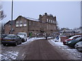
1
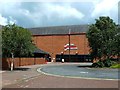
The Sands Centre
A sports and fitness centre at Carlisle.
Image: © Mary and Angus Hogg
Taken: 5 Jul 2014
0.01 miles
2

Cormorant sculpture behind the Sands Centre
Situated on a path beside the River Eden.
A plaque on the left face of the sandstone pillar says 'To commemorate 25 years of the R.S.P.B. Members Group in Carlisle. Grateful thanks to Carlisle City Council - Cumbria County Council - Carlisle Wide Neighbourhood Forum - Cumbria Waste Management Environment Trust'.
There is no indication of who created the sculpture, or when.
Image: © Rose and Trev Clough
Taken: 27 Apr 2014
0.03 miles
4
Flood wall art trail, Sands Centre
Following extensive flooding in Carlisle in January 2005, flood alleviation measures costing £38m were implemented. As well as offering protection, the works were designed to enhance footpaths, cycleways and wildlife habitats. The Environment Agency also commissioned an art work of 40 small enamel plaques, with locally themed designs. These were sited on the flood walls to create a riverside trail, which is shown on the map pictured above. The plaque to the right is 'Flowering rush' by artist Alison White. For further information, see art project manager's website http://cathynewbery.co.uk/portfolio/art-on-the-wall/ .
Sadly, the defences could not hold back the next extreme flood which occurred in December 2015. The water got behind this wall and the leisure centre suffered some damage.
Image: © Rose and Trev Clough
Taken: 8 Apr 2012
0.03 miles
5
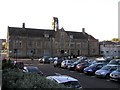
Magistrates Court, Carlisle
It is located at Rickergate
Image: © Kenneth Allen
Taken: 8 Oct 2009
0.05 miles
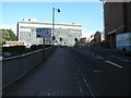
7

Flooded Hardwicke Circus
The morning of the Flooding in Carlisle, Hardwicke Circus under water again
Image: © David Liddle
Taken: 6 Dec 2015
0.06 miles
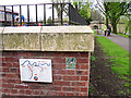
8
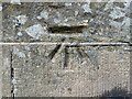
Benchmark, Eden Bridge South Recess
Detail of the Ordnance Survey cut benchmark near the seat at the south end of the east parapet of Eden Bridge, Carlisle. The benchmark marks a height of 18.8458m above Ordnance Datum Newlyn last verified in 1972 (location photograph Image).
Image: © Adrian Taylor
Taken: 10 May 2022
0.06 miles
9
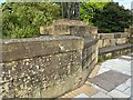
Eden Bridge parapet
Detail of the east parapet of Eden Bridge, Carlisle.
There is an Ordnance Survey cut benchmark on the face of the wall near the wall angle (photograph Image).
Image: © Adrian Taylor
Taken: 10 May 2022
0.06 miles
10
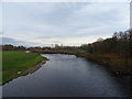
River Eden, Carlisle
From Eden Bridge on the A7.
Image: © JThomas
Taken: 20 Nov 2019
0.06 miles