IMAGES TAKEN NEAR TO
Carleton, PENRITH, CA11 8UA
Introduction
This page details the photographs taken nearby to CA11 8UA by members of the Geograph project.
The Geograph project started in 2005 with the aim of publishing, organising and preserving representative images for every square kilometre of Great Britain, Ireland and the Isle of Man.

There are currently over 7.5m images from over14,400 individuals and you can help contribute to the project by visiting https://www.geograph.org.uk
Image Map
Images are licensed for reuse under creativecommons.org/licenses/by-sa/2.0
Notes
- Clicking on the map will re-center to the selected point.
- The higher the marker number, the further away the image location is from the centre of the postcode.
Image Listing (17 Images Found)
Images are licensed for reuse under creativecommons.org/licenses/by-sa/2.0
Image
Details
Distance
1

Entrance drive to Hunter Hall School from Carleton Road
Ordnance Survey documents indicate that a benchmark was levelled at 371.667 feet above Liverpool Datum on a gatepost at the entrance during the 1844 Penrith to Darlington Survey. The surveyor's description was 'No. 6. Mark on pier of gate to Mr. Phair's house, at North side of road ; 1.71 ft. above surface'. The mark was relevelled at 113.124m above Newlyn Datum in 1972.
Image: © Luke Shaw
Taken: 4 Feb 2020
0.05 miles
2
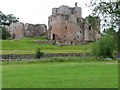
Brougham Castle
The castle is situated in the south to southeastern corner of the grid square, southwest of Penrith in Cumbria. The picture was taken looking eastwards towards the castle from the road.
Image: © Pam Brophy
Taken: 12 Jul 2004
0.07 miles
3
Pasture, Carleton
Beside the A686 just outside of Penrith.
Image: © Andrew Smith
Taken: 21 Dec 2007
0.12 miles
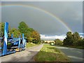
4
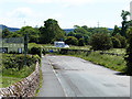
Old and new main roads at Carleton
The old main road (Carleton Road) seemingly comes to an end where it abuts onto the modern A66, but a bridleway continues through a subway under the new road and is followed by National Cycle Network route 71.
Image: © Oliver Dixon
Taken: 11 Jun 2014
0.14 miles
5
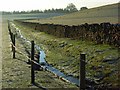
Stream and pasture, Carleton
Showing the conifer plantation to the east of Frenchfield Farm.
Image: © Andrew Smith
Taken: 21 Dec 2007
0.15 miles
6
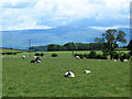
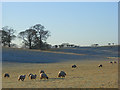
Field with sheep at Carleton
Cross Fell Image dominates the horizon.
Image: © Oliver Dixon
Taken: 11 Jun 2014
0.15 miles
7
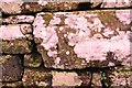
Benchmark on roadside dry stone wall at Carleton Brow
Ordnance Survey cut mark benchmark described on the Bench Mark Database at www.bench-marks.org.uk/bm115948
Image: © Luke Shaw
Taken: 4 Feb 2020
0.18 miles
8
The A686, Penrith
Having just left Carleton village at the start of the enjoyable drive to Alston via Hartside.
Image: © Andrew Smith
Taken: 27 Sep 2007
0.18 miles
9
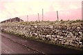
Dry stone wall on NE side of road at Carleton Brow
There is an OS benchmark Image on a stone in the wall
Image: © Luke Shaw
Taken: 4 Feb 2020
0.18 miles
10
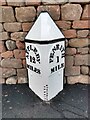
Old Milepost by the former A66, Carleton Road, West of Frenchfield, Penrith Parish
The milestone is located near a barn, at the back of the footpath, against a stone wall, on the East side of road. Metal post with attached metal plates, Appleby plate design, erected by the Brough & Eamont Bridge turnpike trust in the 19th century.
Inscription reads:- APPLEBY / 12 / MILES : : BOWER / PRNR : : PENRITH / 1 / MILE
Carved benchmark on front edge.
The milestone was fully restored by Terry Moore in 2021 with local funding supplemented by a contribution from The Milestone Society.
See also https://www.geograph.org.uk/photo/5623101
Milestone Society National ID: CU_PRAP01
Image: © Terry Moore
Taken: 28 Jun 2021
0.19 miles