IMAGES TAKEN NEAR TO
Manor Park, PENRITH, CA11 8AL
Introduction
This page details the photographs taken nearby to Manor Park, CA11 8AL by members of the Geograph project.
The Geograph project started in 2005 with the aim of publishing, organising and preserving representative images for every square kilometre of Great Britain, Ireland and the Isle of Man.

There are currently over 7.5m images from over14,400 individuals and you can help contribute to the project by visiting https://www.geograph.org.uk
Image Map (Loading...)


Getting Data...Please wait
Leaflet Map data © OpenStreetMap
Images are licensed for reuse under creativecommons.org/licenses/by-sa/2.0
Notes
- Clicking on the map will re-center to the selected point.
- The higher the marker number, the further away the image location is from the centre of the postcode.
Image Listing (10 Images Found)
Images are licensed for reuse under creativecommons.org/licenses/by-sa/2.0
Image
Details
Distance
1
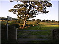
Public Footpath to Scaws and Beacon Edge
Fields on the edge of Penrith that have somehow still escaped the property developer.
Image: © Chris Upson
Taken: 16 Sep 2005
0.08 miles
3
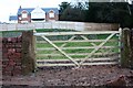
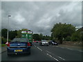
Gateway from A686 at development site
Ordnance Survey records indicate that there was a benchmark cut on one of the gateposts in 1972 levelled at 130.81m above Newlyn Datum - see www.bench-marks.org.uk/bm115947 . The gateway is currently fenced off so the posts could not be inspected
Image: © Luke Shaw
Taken: 4 Feb 2020
0.11 miles
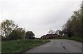
6

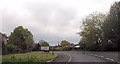
The A686, Penrith
Having just left Carleton village at the start of the enjoyable drive to Alston via Hartside.
Image: © Andrew Smith
Taken: 27 Sep 2007
0.19 miles
8

Pasture, Carleton
Beside the A686 just outside of Penrith.
Image: © Andrew Smith
Taken: 21 Dec 2007
0.21 miles
9
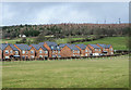
New housing in Penrith
Recently built brick housing on what was a greenfield site; currently, March 2020, OS mapping doesn't show the development.
The trees above are on Beacon Hill.
Image: © Trevor Littlewood
Taken: 9 Mar 2020
0.23 miles
10
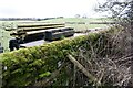
View of fields on south side of A686 east of Carleton
Old maps show that there was an Ordnance Survey benchmark levelled at 398.7 feet above Liverpool Datum on a wall at this location. Widening of the A686 appears have resulted in the loss of the mark.
Image: © Roger Templeman
Taken: 19 Feb 2020
0.24 miles