IMAGES TAKEN NEAR TO
Sandgate, PENRITH, CA11 7TW
Introduction
This page details the photographs taken nearby to Sandgate, CA11 7TW by members of the Geograph project.
The Geograph project started in 2005 with the aim of publishing, organising and preserving representative images for every square kilometre of Great Britain, Ireland and the Isle of Man.

There are currently over 7.5m images from over14,400 individuals and you can help contribute to the project by visiting https://www.geograph.org.uk
Image Map
Images are licensed for reuse under creativecommons.org/licenses/by-sa/2.0
Notes
- Clicking on the map will re-center to the selected point.
- The higher the marker number, the further away the image location is from the centre of the postcode.
Image Listing (368 Images Found)
Images are licensed for reuse under creativecommons.org/licenses/by-sa/2.0
Image
Details
Distance

2
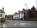
Meeting House Lane, Penrith
Meeting House Lane is close to the centre of Penrith, in Cumbria.
Image: © Malc McDonald
Taken: 25 Apr 2015
0.01 miles
3

14 -17, Meeting House Lane
Grade II listed.
Image: © N Chadwick
Taken: 22 May 2022
0.03 miles
4

Benchmark on Zion Chapel, Fell Lane
Ordnance Survey cut mark benchmark described on the Bench Mark Database at http://www.bench-marks.org.uk/bm38753
Image: © Roger Templeman
Taken: 30 May 2015
0.03 miles
5
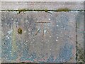
Benchmark, Penrith, Zion Chapel
Detail of the Ordnance Survey cut benchmark on the sandstone wall in front of the former Zion Chapel, now converted into apartments. The benchmark marks a height of 133.0208m above sea level (Ordnance Datum Newlyn) last verified and levelled in 1972 (location photograph Image).
Image: © Adrian Taylor
Taken: 9 Apr 2021
0.03 miles
6

Wall and litter bin
The sandstone wall is in front of the former Zion Chapel at the corner of Fell Lane and Benson Row, now converted into apartments. To the left of the litter bin there is an Ordnance Survey cut benchmark on the face of the wall (photograph Image).
Image: © Adrian Taylor
Taken: 9 Apr 2021
0.03 miles
7

Ordnance Survey Cut Mark
This OS cut mark can be found on the wall of the Zion Chapel. It marks a point 133.021m above mean sea level.
Image: © Adrian Dust
Taken: 14 Sep 2022
0.03 miles
8

Zion Chapel, Fell Lane at Benson Row junction
There is an OS benchmark Image on the chapel wall left of the keep right sign
Image: © Roger Templeman
Taken: 30 May 2015
0.03 miles
9
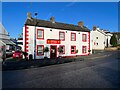
The old Freemason's Arms
The north eastern part of this building facing onto Sandgate, to the right of the entrance door, was formerly the Freemasons Arms public house. It is now a Chinese takeaway.
There is an old Ordnance Survey cut benchmark on the plinth of the left hand door pillar (detail photograph Image).
Image: © Adrian Taylor
Taken: 9 Dec 2022
0.05 miles
10

Benchmark, 5 Sandgate, Penrith
Detail of the old Ordnance Survey cut benchmark on the plinth of the door pillar of 5 Sandgate, Penrith, formerly the Freemason’s Arms public house.
The benchmark, not listed on the Ordnance Survey database, is recorded as marking a height of 421.3 feet above Ordnance Datum Liverpool (0.650ft below mean sea level) on the 1861 Ordnance Survey first edition town map of Penrith (location photograph Image).
Image: © Adrian Taylor
Taken: 9 Dec 2022
0.05 miles