IMAGES TAKEN NEAR TO
Tinkers Cutting, PENRITH, CA11 0FE
Introduction
This page details the photographs taken nearby to Tinkers Cutting, CA11 0FE by members of the Geograph project.
The Geograph project started in 2005 with the aim of publishing, organising and preserving representative images for every square kilometre of Great Britain, Ireland and the Isle of Man.

There are currently over 7.5m images from over14,400 individuals and you can help contribute to the project by visiting https://www.geograph.org.uk
Image Map
Images are licensed for reuse under creativecommons.org/licenses/by-sa/2.0
Notes
- Clicking on the map will re-center to the selected point.
- The higher the marker number, the further away the image location is from the centre of the postcode.
Image Listing (9 Images Found)
Images are licensed for reuse under creativecommons.org/licenses/by-sa/2.0
Image
Details
Distance
1
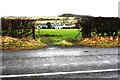
View through field gateway towards Station Road houses
There is an Ordnance Survey benchmark Image on the right hand gatepost of the gateway
Image: © Roger Templeman
Taken: 19 Feb 2020
0.09 miles
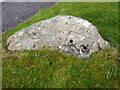
2
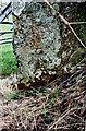
Benchmark on gatepost on north side of road north of Penruddock
Ordnance Survey cut mark benchmark described on the Bench Mark Database at www.bench-marks.org.uk/bm86959 . The mark is a survivor of the 1855/6 Penrith to Workington survey which was levelled at 911.567 feet above Liverpool Datum. The surveyor's description was 'Mark on East pier of gate opposite junction of road to Penruddock'
Image: © Roger Templeman
Taken: 19 Feb 2020
0.18 miles
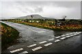
3
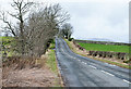
Minor road west of Penruddock
The road was once the route of the A66 before its realignment to pass south of the village.
Image: © Trevor Littlewood
Taken: 9 Mar 2020
0.18 miles
4
Footpath Motherby
The footpath leading from the B5288 at Motherby.
Image: © Steve Houldsworth
Taken: 15 Oct 2011
0.19 miles
5
Old Boundary Marker on the B5288 in Motherby
Township Boundary Marker on the verge on the southeast side of the B5288 in Motherby, outside Stag Cottage West. Until 1866 this was the boundary of Motherby and Gill and Hutton Soil townships, then Greystoke and Hutton Soil parishes until 1934, then Greystoke and Hutton parishes. Now entirely in Hutton parish. The plate on the south side is now missing. The stone is inscribed MDII (1502 if these are Roman numerals) on the north side.
Milestone Society National ID: CU_HUTT02pb
Image: © Colin Smith
Taken: 19 Mar 2015
0.20 miles
6
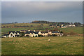
Motherby
View of Motherby from the old A66 north-west of Penruddock.
Image: © Peter McDermott
Taken: 15 Nov 2011
0.20 miles
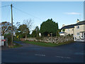
8
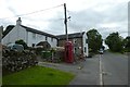
Herdwick Inn
Looking through the village of Penruddock.
Image: © DS Pugh
Taken: 11 Jul 2020
0.22 miles
9
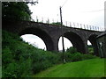
Disused Railway Viaduct Penruddock
This redundant bridge served the now long dismantled railway which connected Penrith via Keswick with Cockermouth and beyond. The picture was taken from the well kept green grass area of the public footpath which leads on under the old viaduct.
Image: © Tom Howard
Taken: 1 Aug 2012
0.24 miles