IMAGES TAKEN NEAR TO
Temple Sowerby, PENRITH, CA10 2AW
Introduction
This page details the photographs taken nearby to CA10 2AW by members of the Geograph project.
The Geograph project started in 2005 with the aim of publishing, organising and preserving representative images for every square kilometre of Great Britain, Ireland and the Isle of Man.

There are currently over 7.5m images from over14,400 individuals and you can help contribute to the project by visiting https://www.geograph.org.uk
Image Map
Images are licensed for reuse under creativecommons.org/licenses/by-sa/2.0
Notes
- Clicking on the map will re-center to the selected point.
- The higher the marker number, the further away the image location is from the centre of the postcode.
Image Listing (22 Images Found)
Images are licensed for reuse under creativecommons.org/licenses/by-sa/2.0
Image
Details
Distance
1
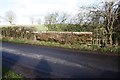
Bridge parapet on minor road near Swine Gill Cottages
Image: © Roger Templeman
Taken: 4 Feb 2020
0.06 miles
2
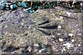
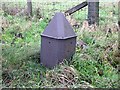
Benchmark on top of SW parapet of bridge NW of Swine Gill Cottages
Ordnance Survey pivot benchmark described on the Bench Mark Database at www.bench-marks.org.uk/bm115993. It appears that the coping stone with the mark has been moved from the parapet on the NE side of the road where it should be according to OS documents and maps.
Image: © Luke Shaw
Taken: 4 Feb 2020
0.06 miles
3
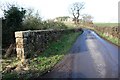
Parapet of bridge on SW side of road approaching Low Woodside
There is an OS benchmark Image on top of the parapet
Image: © Luke Shaw
Taken: 4 Feb 2020
0.07 miles
4
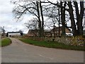
Winderwath Farm
Immediately north of the old [and new] A66.
Image: © Christine Johnstone
Taken: 26 Mar 2018
0.07 miles
5
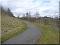
Cycle path descending from the A66 at Winderwath Farm
Allowing cyclists to use the former A66, rather than the dual carriageway Temple Sowerby by-pass [opened 2007].
Image: © Christine Johnstone
Taken: 26 Mar 2018
0.09 miles
6
Old Milepost by the former A66, Brougham parish
Metal post with lost metal plates by the UC road (was A66), in parish of BROUGHAM (EDEN District), near Winderwath Farm, on grass verge, on West side of road. Appleby plate, erected by the Brough & Eamont Bridge turnpike trust in the 19th century. Probably originally located at GR: Image on the modern A66 by Swine Gill Plantation, North side of road.
Inscription once read:-
: (APPLEBY / 9 / MILES) : : (PENRITH / 4 / MILES) :
Milestone Society National ID: WE_PRAP05.
Image: © CF Smith
Taken: 13 Dec 2005
0.10 miles
7
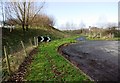
Bend at junction with cycle way near Winderwath Farm
Before the construction of the A66 there was a T-junction here. In 1844 the Ordnance Survey cut a benchmark (see www.bench-marks.org.uk/bm67383 ) on the south side of the road; the mark is shown on the 1860 Map, but is no longer there.
Image: © Luke Shaw
Taken: 4 Feb 2020
0.11 miles
8
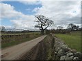
The road from Woodside to Winderwath
A narrow country lane running approximately parallel to the A66.
Image: © Christine Johnstone
Taken: 26 Mar 2018
0.12 miles
9
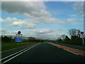
Start of the dual carriageway on the A66
Image: © Andrew Abbott
Taken: 15 May 2010
0.12 miles
10
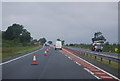
Approaching the end of the Temple Sowerby Bypass
Image: © N Chadwick
Taken: 23 Jun 2012
0.12 miles