IMAGES TAKEN NEAR TO
Beechill Park West, BELFAST, BT8 6NU
Introduction
This page details the photographs taken nearby to Beechill Park West, BT8 6NU by members of the Geograph project.
The Geograph project started in 2005 with the aim of publishing, organising and preserving representative images for every square kilometre of Great Britain, Ireland and the Isle of Man.

There are currently over 7.5m images from over14,400 individuals and you can help contribute to the project by visiting https://www.geograph.org.uk
Image Map
Images are licensed for reuse under creativecommons.org/licenses/by-sa/2.0
Notes
- Clicking on the map will re-center to the selected point.
- The higher the marker number, the further away the image location is from the centre of the postcode.
Image Listing (23 Images Found)
Images are licensed for reuse under creativecommons.org/licenses/by-sa/2.0
Image
Details
Distance
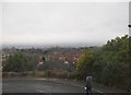
1
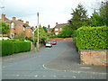
Beechill Park, Belfast
One of the many streets that sprung up here around the Four Winds in the late 1960s. Off the old Saintfield Road.
Image: © Dean Molyneaux
Taken: 24 Sep 2009
0.09 miles
2
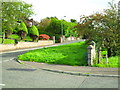
The old Saintfield Road at Beechill, Belfast
Replaced in the 1960s by much smoother road, the old Saintfield Road serves many houses and streets in the older part of the Four Winds area.
Image: © Dean Molyneaux
Taken: 24 Sep 2009
0.09 miles
3
Saintfield Road at Whinney Heights, Belfast
Both the old and new Saintfield Roads. The one on the right is the main A24 - linking Belfast with South Down (Newcastle and Downpatrick).
Image: © Dean Molyneaux
Taken: 24 Sep 2009
0.10 miles
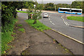
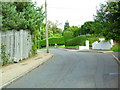
4
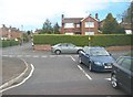
Entrance to Beechfield Park off Saintfield Road, Cairnshill
The grey car is on the Old Saintfield Road.
Image: © Eric Jones
Taken: 27 Apr 2012
0.10 miles
5
Commons Brae, Belfast (2)
The name sign at the Saintfield Road end of Commons Brae Image The street has a postal address of Belfast BT8 but lies within the borough of Castlereagh and is, therefore, outside this shared description http://www.geograph.org.uk/snippet/4658
Image: © Albert Bridge
Taken: 21 Sep 2011
0.12 miles
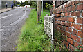
6
Commons Brae, Belfast (1)
A steep stretch of suburban road, running from the (almost as steep) Saintfield Road (background). Image shows the name sign.
Image: © Albert Bridge
Taken: 21 Sep 2011
0.12 miles
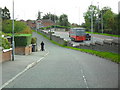
7
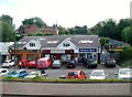
Suburban shops and businesses off the A24 at Newtownbreda
Image: © Eric Jones
Taken: 10 Jul 2015
0.13 miles
8
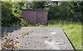
Valve well, Belfast
Belfast & District Water Commissioners old (and almost certainly disused) valve well on the Saintfield Road in Belfast.
Image: © Rossographer
Taken: 29 May 2016
0.13 miles
9
Entrance to Woodbreda Park
Woodbreda is a modern housing estate in the outer suburbs of Belfast.
Image: © Eric Jones
Taken: 15 Feb 2012
0.13 miles
10
Commons Brae, Belfast
Once a steep cul-de-sac off the Saintfield Road, it now links onto Burnside Avenue.
Image: © Dean Molyneaux
Taken: 24 Sep 2009
0.13 miles