IMAGES TAKEN NEAR TO
Kerrymount Avenue, BELFAST, BT8 6NL
Introduction
This page details the photographs taken nearby to Kerrymount Avenue, BT8 6NL by members of the Geograph project.
The Geograph project started in 2005 with the aim of publishing, organising and preserving representative images for every square kilometre of Great Britain, Ireland and the Isle of Man.

There are currently over 7.5m images from over14,400 individuals and you can help contribute to the project by visiting https://www.geograph.org.uk
Image Map
Images are licensed for reuse under creativecommons.org/licenses/by-sa/2.0
Notes
- Clicking on the map will re-center to the selected point.
- The higher the marker number, the further away the image location is from the centre of the postcode.
Image Listing (17 Images Found)
Images are licensed for reuse under creativecommons.org/licenses/by-sa/2.0
Image
Details
Distance
1
Alt-Min Avenue, Four Winds, Belfast
A cul-de-sac off Carnbrae Avenue.
Image: © Dean Molyneaux
Taken: 24 Sep 2009
0.09 miles
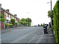
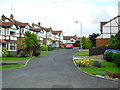
2
Carnbrae Avenue, Four Winds, Belfast
A peaceful street off Newton Park in Belfast 8. It carries on to loop back to Newton Park at Glenholm.
Image: © Dean Molyneaux
Taken: 24 Sep 2009
0.13 miles
3
Cairnshill Road, Four Winds, Belfast
This road was realigned and widened in 1986 to cope with the demands of this fast-growing suburb. Looking towards the Four Winds roundabout.
Image: © Dean Molyneaux
Taken: 24 Sep 2009
0.15 miles
4
Newton Heights, Four Winds, Belfast
A development of semis of the Cairnshill Road.
Image: © Dean Molyneaux
Taken: 24 Sep 2009
0.16 miles
5
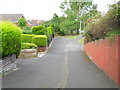
The old line of the Cairnshill Road, Belfast
In 1986, with 100s of homes being built by Fraser Homes Ltd (Malvern and Rossdale developments), the Cairnshill Road was widened, realigned and raised to meet the demand. The narrower old road is now incorporated into Newton Heights, except this out of place stretch of pavement.
Image: © Dean Molyneaux
Taken: 24 Sep 2009
0.18 miles
6
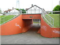
Subway under the Cairnshill Road, Belfast
When the Fraser Homes Ltd developments of Malvern and Rossdale were in full swing in the mid-1980s, the need arose to widen the narrow Cairnshill Road. The road was realigned and raised. To provide pedestrian access between Newton Heights, which was built in the early 1980s on the same line as the old road, and Rossdale - this subway was built.
It's been repainted since the last time I was here in 2004 - apart from the several graffiti tags, it looks quite well - every light in working order as well.
Image: © Dean Molyneaux
Taken: 24 Sep 2009
0.18 miles
7
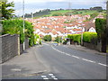
Cairnshill Road at Pennington Park, Belfast
The Cairnshill Road was widened and realigned in 1986 in order to meet the demands of the massive Fraser Homes development (nearly every house in this picture).
Image: © Dean Molyneaux
Taken: 24 Sep 2009
0.20 miles
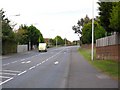
8
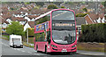
Bus, Cairnshill Road, Belfast (April 2017)
A Metro Wright-bodied Volvo (2384 SFZ 9384) running along the Cairnshill Road with a 7A Four Winds – Howard Street service.
Image: © Albert Bridge
Taken: 20 Apr 2017
0.20 miles
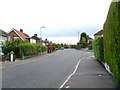
9
Rossdale Gardens, Four Winds, Belfast
The Rossdale development (1986/7 - Fraser Homes Ltd.) is characterised by the mock-Tudor exteriors.
Image: © Dean Molyneaux
Taken: 24 Sep 2009
0.21 miles
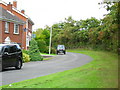
10

Newton Park, Four Winds, Belfast
One of the main thoroughfares in the Four Winds area - seen here at Carnbrae Avenue.
Image: © Dean Molyneaux
Taken: 24 Sep 2009
0.21 miles