IMAGES TAKEN NEAR TO
Church View Way, CRAIGAVON, BT63 6DH

Introduction

This page details the photographs taken nearby to Church View Way, BT63 6DH by members of the Geograph project.

The Geograph project started in 2005 with the aim of publishing, organising and preserving representative images for every square kilometre of Great Britain, Ireland and the Isle of Man.

There are currently over 7.5m images from over14,400 individuals and you can help contribute to the project by visiting https://www.geograph.org.uk

Image Map


Images are licensed for reuse under creativecommons.org/licenses/by-sa/2.0
Notes
  • Clicking on the map will re-center to the selected point.
  • The higher the marker number, the further away the image location is from the centre of the postcode.

Image Listing (12 Images Found)

Images are licensed for reuse under creativecommons.org/licenses/by-sa/2.0
Image
Details
Distance
1
The River Bann at Laurencetown (1)
The view upstream of the Bann, from the Point Road, as it approaches the weir behind the long-closed Hazelbank mill. The autumn colours are now starting to appear along the riverbank. There are two spellings – one with a “w” and one with a “u”. The official usage now seems to lean towards the former but I was brought up with the latter and intend to continue using it.
Image: © Albert Bridge Taken: 15 Oct 2013
0.14 miles
2
Former Chapel Row level crossing, Laurencetown
The site of the former Chapel Row level crossing where the Banbridge (left) – Scarva line (closed 1955) crossed the Point Road Image All trace has now gone but the course is marked by the wooden fence at middle right. The Google map is representational only. Subject positioned using the satellite photograph. Image shows the course of the line immediately on the Scarva side of the crossing.
Image: © Albert Bridge Taken: 15 Oct 2013
0.16 miles
3
Course of old railway, Laurencetown
The course of the Banbridge – Scarva line (closed 1955) - right) immediately after it had crossed the Point Road by this level crossing Image, is still clearly visible (lower right). The line continued towards Laurencetown station and Scarva by a bridge across the Bann (left). The bridge has gone but an abutment remains just above the river at upper left – see also Image The Google map is representational only. Subject positioned using the satellite photograph.
Image: © Albert Bridge Taken: 15 Oct 2013
0.17 miles
4
The Point Road, Laurencetown
The Point Road is a minor road, running south east, off the Banbridge – Portadown road. This view is towards Drumnagally and Ballykeel townlands from the bridge across the Bann Image The autumn colours are now starting to appear along the riverbank. There are two spellings – one with a “w” and one with a “u”. The official usage now seems to lean towards the former but I was brought up with the latter and intend to continue using it.
Image: © Albert Bridge Taken: 15 Oct 2013
0.17 miles
5
The River Bann at Laurencetown (2)
The River Bann, looking downstream from the bridge on the Point Road Image The Banbridge – Scarva line (closed 1955) crossed from here Image lower right. The only remaining trace is the bridge abutment, just above the river, at middle left.
Image: © Albert Bridge Taken: 15 Oct 2013
0.18 miles
6
St Patrick's and St Colman's church, Laurencetown
A Roman Catholic church at the corner of the Point Road (right in Image). A long description in the list of listed buildings includes “A double height cruciform plan Gothic style Roman Catholic Church pre-dating 1830; bell tower added 1912; extensively renovated 1966”. There is a more detailed history in the church’s own website http://www.tullylish.com/churches/laurencetown/15-st-patrick-and-st-colmans-church.
Image: © Albert Bridge Taken: 15 Oct 2013
0.19 miles
7
Notice Board, Tullylish Presbyterian Church
The church dates back to 1786. The church has seen some refurbishing since then.
Image: © P Flannagan Taken: 28 Jun 2008
0.21 miles
8
Hazelbank Mill
Hazelbank Mill, located beside the River Bann, was listed as a bleach mill in the first OS Maps. In the Griffith Maps it was a spinning mill. By 1878 a weaving mill had been added although the mill was at that time disused. Today, the mill houses a hydroelectric plant and a heat exchanger (neither of them are in this building though).
Image: © Mike Simms Taken: 24 Jun 2017
0.22 miles
9
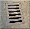
Samuel Finney grating cover, Laurencetown
A grating cover, on the Point Road Image, marked “Samuel Finney Banbridge County Down Pattern” http://www.geograph.org.uk/search.php?i=44350598. Samuel Finney was, to the best of my knowledge, a builder’s merchant.
Image: © Albert Bridge Taken: 15 Oct 2013
0.23 miles
10
Fire hydrant marker, Laurencetown
See Image Another section control valve post surviving from the era of Banbridge Rural District Council. This one is on the Point Road Image
Image: © Albert Bridge Taken: 15 Oct 2013
0.23 miles