IMAGES TAKEN NEAR TO
Bloomfield Road, BELFAST, BT5 5LR
Introduction
This page details the photographs taken nearby to Bloomfield Road, BT5 5LR by members of the Geograph project.
The Geograph project started in 2005 with the aim of publishing, organising and preserving representative images for every square kilometre of Great Britain, Ireland and the Isle of Man.

There are currently over 7.5m images from over14,400 individuals and you can help contribute to the project by visiting https://www.geograph.org.uk
Image Map
Images are licensed for reuse under creativecommons.org/licenses/by-sa/2.0
Notes
- Clicking on the map will re-center to the selected point.
- The higher the marker number, the further away the image location is from the centre of the postcode.
Image Listing (204 Images Found)
Images are licensed for reuse under creativecommons.org/licenses/by-sa/2.0
Image
Details
Distance
1
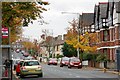
The Bloomfield Road, Belfast
The Bloomfield Road runs from the Beersbridge Road to the North Road. It is entirely residential except for a few shops at the roundabout at the North Road end. The view is towards the North Road.
Image: © Albert Bridge
Taken: 31 Oct 2007
0.02 miles
2
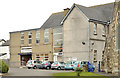
Bramcote Street, Belfast
A street, running from the Bloomfield Road to Grace Avenue Image (background), It was built over a number of years in the early 20th century although some of the odd-numbered houses are a bit later.
Image: © Albert Bridge
Taken: 2 Jun 2011
0.03 miles
3

Volkswagen Beetle, Belfast
See Image (April 2010). The successor is not the MkII New Beetle but simply “The Beetle” proving that it’s possible to improve on perfection. Wiki link here http://en.wikipedia.org/wiki/Volkswagen_Beetle_(A5)
Image: © Albert Bridge
Taken: 14 Aug 2013
0.03 miles
4

Melrose Avenue sign, Belfast
Cast sign at the Woodcot Avenue end of Melrose Avenue, off the Beersbridge Road.
Image: © Albert Bridge
Taken: 28 Mar 2011
0.03 miles
5
Halls, St Donard's church, Belfast (2)
See Image The existing church hall. This photograph appears as a matter of geographical and historical record only and does make any comment, for or against, the application referred to in the previous photograph. The church Image is on the right. The view is from the Beersbridge Road. Continue to Image
Image: © Albert Bridge
Taken: 1 Apr 2013
0.04 miles
6
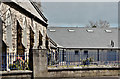
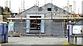
St Donard's Church of Ireland, Belfast (April 2016)
The Bloomfield Road side of St Donard’s Church of Ireland Image after replacement of the church halls Image
Image: © Albert Bridge
Taken: 27 Apr 2016
0.05 miles
7
Halls, St Donard's church, Belfast (1)
The view from the Beersbridge Road. There is currently the following application for planning permission: “0244/LBC St Donard's Church , 2-10 Bloomfield Road, Belfast Demolition of Youth Hall”. There is also a previous application “Z/2012/1287/F St. Donard's Church 2-10 Bloomfield Road Belfast BT5 5LT Proposed new Parish Centre for St Donard's Parish Church. Proposal involves the demolition of existing Youth Hall. New Parish Centre to be single storey and linked to existing Church Building”. This photograph appears as a matter of geographical and historical record only and does make any comment, for or against, the application. Image shows the church. See also Image
Image: © Albert Bridge
Taken: 1 Apr 2013
0.06 miles
8
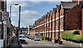
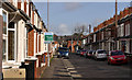
Glenbrook Avenue, Belfast (1)
A street of late 19th century terrace houses, running from Grace Avenue Image to the Bloomfield Road Image (at the bus – background).
Image: © Albert Bridge
Taken: 2 Jun 2011
0.06 miles
9
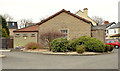
New St Donard's church hall, Belfast (March 2015)
See Image and Image (April 2013). The replacement hall now under construction beside the Beersbridge Road.
Image: © Albert Bridge
Taken: 28 Mar 2015
0.06 miles
10
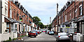
Kensington Avenue, Belfast
A street of terrace houses, built around the end of the 19th century, running from Grace Avenue Image to the Bloomfield Road Image (background). It was once suggested to me that the houses were built to for bakery workers but the street directories show that the occupants had a wide range of employment.
Image: © Albert Bridge
Taken: 5 Mar 2012
0.07 miles