IMAGES TAKEN NEAR TO
Harbour Road, BALLYCASTLE, BT54 6NA
Introduction
This page details the photographs taken nearby to Harbour Road, BT54 6NA by members of the Geograph project.
The Geograph project started in 2005 with the aim of publishing, organising and preserving representative images for every square kilometre of Great Britain, Ireland and the Isle of Man.

There are currently over 7.5m images from over14,400 individuals and you can help contribute to the project by visiting https://www.geograph.org.uk
Image Map
Images are licensed for reuse under creativecommons.org/licenses/by-sa/2.0
Notes
- Clicking on the map will re-center to the selected point.
- The higher the marker number, the further away the image location is from the centre of the postcode.
Image Listing (152 Images Found)
Images are licensed for reuse under creativecommons.org/licenses/by-sa/2.0
Image
Details
Distance
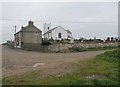
1
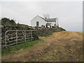
Ballintoy Parish Church viewed from the road descending towards the harbour
The field in the foreground is newly harvested.
http://www.ballintoy.connor.anglican.org/ballintoychurch.html
Image: © Eric Jones
Taken: 25 Sep 2013
0.00 miles
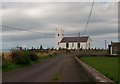
2

Ballintoy Parish Church
http://www.ballintoy.connor.anglican.org/ballintoychurch.html
Image: © Eric Jones
Taken: 23 Sep 2013
0.00 miles
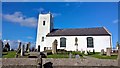
3
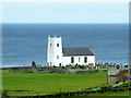
Ballintoy Parish Church
The distinctive white Ballintoy Parish Church on the hill above the Harbour was completed in 1813 as a replacement for an older structure, the tower of which was retained.
Image: © David Dixon
Taken: 28 Sep 2017
0.00 miles
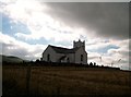
4
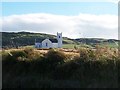
Ballintoy Parish Church from the north
This image was taken from the road descending down to Ballintoy Harbour.
Image: © Eric Jones
Taken: 23 Sep 2013
0.00 miles
5
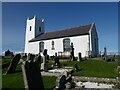
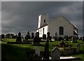
Ballintoy Parish Church
The Church is the main Church of Ireland church of Ballintoy, County Antrim, Northern Ireland. The church, located a short distance from the town, is one of the most northerly churches in the Diocese of Connor.
Image: © Russel Wills
Taken: 16 Sep 2023
0.00 miles
6
Ballintoy Parish Church and graveyard viewed from the east
The harbour road borders the graveyard on two sides.
http://www.ballintoy.connor.anglican.org/ballintoychurch.html
Image: © Eric Jones
Taken: 25 Sep 2013
0.01 miles
8
Ballintoy Parish Church from the Harbour Road
There has been a church on the site since Pre-Reformation days. During the 1641 Catholic Revolt the Protestant people of the area sought refuge in the church and were secretly fed by Fr McGlaime, a local Catholic priest until in the following year they were rescued by Lord Antrim's forces.
http://fineartamerica.com/featured/church-harvest-ballintoy-paul-morgan.html
Image: © Eric Jones
Taken: 23 Sep 2013
0.01 miles
9
Ballintoy Parish Church
This church was built in 1813 and replaced an earlier structure. Some distance from the modern village it is immediately above the picturesque harbour. Views from the cliffs are spectacular.
Image: © Chris Morgan
Taken: 13 Oct 2016
0.01 miles
10
Ballintoy Parish Church and Graveyard
http://www.ballintoy.connor.anglican.org/ballintoychurch.html
Image: © Eric Jones
Taken: 23 Sep 2013
0.01 miles