IMAGES TAKEN NEAR TO
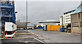
Sydenham Road, BELFAST, BT3 9HA
Introduction
This page details the photographs taken nearby to Sydenham Road, BT3 9HA by members of the Geograph project.
The Geograph project started in 2005 with the aim of publishing, organising and preserving representative images for every square kilometre of Great Britain, Ireland and the Isle of Man.

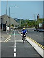
There are currently over 7.5m images from over14,400 individuals and you can help contribute to the project by visiting https://www.geograph.org.uk
Image Map
Images are licensed for reuse under creativecommons.org/licenses/by-sa/2.0
Notes
- Clicking on the map will re-center to the selected point.
- The higher the marker number, the further away the image location is from the centre of the postcode.
Image Listing (511 Images Found)
Images are licensed for reuse under creativecommons.org/licenses/by-sa/2.0
Image
Details
Distance
1
The Old Channel Road, Belfast (1)
Belfast harbour has seen many changes since the building of the first quay in 1613. Major redevelopment started in the mid-1800’s and continued with the growth of industrial Belfast. The Old Channel Road, which runs parallel to the Sydenham Road Image and is close to the Harland & Wolff building dock http://www.geograph.org.uk/snippet/4650 seems to have come into existence towards the end of the 19th century as a site for a coal yard. Now remote from the main dry-cargo handling area, on the other side of the Lagan, it is the site of various businesses, notably connected with construction.
The view is towards Queen’s Quay. Buildings (for reference points) in the background are: the Obel Tower Image (on the right of the scaffolding), the Odyssey Image (middle right) and the Gateway Building Image (second right). Continue to Image
Image: © Albert Bridge
Taken: 31 Jul 2011
0.01 miles
2
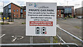
Car park, Belfast
Car park for the now defunct (and demolished) Carillion site in Belfast. See also Image I've no idea why users were instructed to reverse park only....
Image: © Rossographer
Taken: 10 Oct 2020
0.03 miles
3
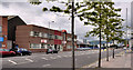
The Sydenham Road, Belfast
Part of the southern side of a commercial road, running from Dee Street Image towards Queen’s Quay (background).
Image: © Albert Bridge
Taken: 11 Jul 2011
0.04 miles
4
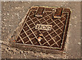
"BCG" access cover, Belfast (1)
There are still some access covers, in various parts of Belfast, bearing the initials “BCG” (Belfast Corporation Gas). The “G” is quite clear on this one, on the Sydenham Road but in some cases the “G” has a resemblance to a “C” Image for example.
Image: © Albert Bridge
Taken: 24 Feb 2011
0.04 miles
5
Sydemham Rd, Belfast.
The new two-way cycle lane on the re-vamped Sydenham Rd installed during May 2013 to provide a much-needed link from the Titanic Quarter to the Comber Greenway at Dee St. It also continues on to the Airport Rd which provides a quieter cycle route to Holywood, passing the RSPB Harbour Estate bird reserve on the way.
Image: © Robert Ashby
Taken: 25 May 2013
0.05 miles
6
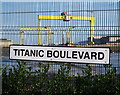
Titanic Boulevard, Belfast
Street sign for 'Titanic Boulevard', a short and newly created street running between Sydenham Road and Queen's Road in Belfast's Titanic Quarter. At the time of writing the Google maps have not caught up with it. Behind the fence can be glimpsed the Building Dock and Harland and Wolff with the gantry cranes 'Samson' and 'Goliath' towering above.
Image: © Rossographer
Taken: 16 Dec 2012
0.06 miles
7
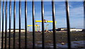
Redevelopment area, Belfast
Another part of the 'Titanic Quarter' area of Belfast, this is cleared but as yet undeveloped land between the Sydenham Road and Queen's Road. The building dock at Harland and Wolff is in the background. A few years ago it contained a clutter of building materials which have since either been moved or used on other projects Image
Image: © Rossographer
Taken: 16 Dec 2012
0.06 miles
8

Buddleia, Belfast
Buddleia growing through an old fence, on the Sydenham Road, around the Harland & Wolff building dock. The crane “Goliath” Image is in the background.
Image: © Albert Bridge
Taken: 11 Jul 2011
0.06 miles
9
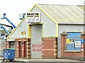
Beattie Crane Hire, Belfast (May 2018)
BHC/Beattie Crane Hire http://www.bchc.ltd.uk/ at 31 Sydenham Road. See also Image
I have no connection with the business.
Image: © Albert Bridge
Taken: 4 May 2018
0.06 miles
10
Olympic House site, Belfast - November 2014(1)
There is still no news about when development of the site will start. This view is from the Sydenham Road opposite the Titanic Boulevard (left – Sydenham Road on the Google map). The site has been cleared and tidied since this shot Image in October 2010.
Image: © Albert Bridge
Taken: 1 Nov 2014
0.06 miles