IMAGES TAKEN NEAR TO
Ransevyn Park, CARRICKFERGUS, BT38 9LY
Introduction
This page details the photographs taken nearby to Ransevyn Park, BT38 9LY by members of the Geograph project.
The Geograph project started in 2005 with the aim of publishing, organising and preserving representative images for every square kilometre of Great Britain, Ireland and the Isle of Man.

There are currently over 7.5m images from over14,400 individuals and you can help contribute to the project by visiting https://www.geograph.org.uk
Image Map
Images are licensed for reuse under creativecommons.org/licenses/by-sa/2.0
Notes
- Clicking on the map will re-center to the selected point.
- The higher the marker number, the further away the image location is from the centre of the postcode.
Image Listing (42 Images Found)
Images are licensed for reuse under creativecommons.org/licenses/by-sa/2.0
Image
Details
Distance
1
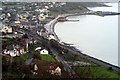
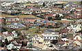
Whitehead from the Bla' Hole
View of Whitehead Town from the Bla' Hole
Image: © Wilson Adams
Taken: 22 Oct 2005
0.02 miles
2
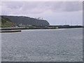
Clachan Rock Car Park.
This photo was taken from just inside the southern edge of the square looking towards Black Head Lighthouse.
Image: © Paul McIlroy
Taken: 22 Oct 2005
0.02 miles
3
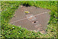
"Darby Selflock" access cover, Whitehead
A Darby “Selflock” access cover at the Islandmagee Road end of Rasnevyn Drive. My amateur research (which might be completely wrong) suggests that the name originated with Abraham Darby http://en.wikipedia.org/wiki/Abraham_Darby_I and after closure was acquired by Glynwed http://www.geograph.org.uk/search.php?i=41158277 which is now part of the PAM Saint-Gobain Group Image The specification “D400” refers to “access covers and gratings capable of withstanding a 40 tonnes test load. For use in areas where cars and lorries have access, including carriageways, hard shoulders and pedestrian areas”.
Image: © Albert Bridge
Taken: 27 Apr 2013
0.11 miles
4

Donegall Rise, Whitehaven
The Cloughan oil jetty feeding Kilroot Power Station features prominently in the background. The headland on the right is White Head.
Image: © Eric Jones
Taken: 30 Jun 2017
0.11 miles
5
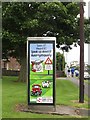
Northern Ireland Crime Stoppers Rural Crime Ad
Rural crime is rife in Ireland, North and South, with stolen livestock and equipment being spirited across the border and often shipped on to GB and Europe as well as further afield.
Image: © Eric Jones
Taken: 30 Jun 2017
0.11 miles
6
Whitehead from the Bla Hole (2)
See Image Today’s view, north, from the Bla Hole Image The Islandmagee Road is about the middle of the photo with the bowling green at middle left. The fire station Image training tower is the green object (middle bottom) and Castle Chester is the stone structure at bottom right.
Image: © Albert Bridge
Taken: 17 Mar 2010
0.14 miles
7
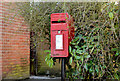
Letter box, Whitehead
Post-mounted EIIR letter box (BT38 287) outside a shop on the Islandmagee Road.
Image: © Albert Bridge
Taken: 27 Apr 2013
0.14 miles
8
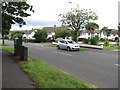
The Lumford Avenue junction on Ransevyn Drive
Image: © Eric Jones
Taken: 30 Jun 2017
0.14 miles
9
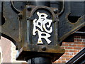
BNCR, Whitehead
At first I thought that this was some sort of Chinese character but the inter-twined capital letters BNCR represent Belfast Northern Counties Railway
Pictured here Image]
Image: © Kenneth Allen
Taken: 28 Mar 2016
0.14 miles
10
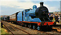
"Slieve Gullion" at Whitehead
Preserved ex-GNR(I) steam locomotive no 171 “Slieve Gullion” at the Railway Preservation Society of Ireland’s depot at Whitehead, during one of the Society’s open days.
Image: © Albert Bridge
Taken: 27 Jun 1970
0.14 miles