IMAGES TAKEN NEAR TO
Hartley Hall, CARRICKFERGUS, BT38 8ZR
Introduction
This page details the photographs taken nearby to Hartley Hall, BT38 8ZR by members of the Geograph project.
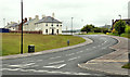
The Geograph project started in 2005 with the aim of publishing, organising and preserving representative images for every square kilometre of Great Britain, Ireland and the Isle of Man.

There are currently over 7.5m images from over14,400 individuals and you can help contribute to the project by visiting https://www.geograph.org.uk
Image Map
Images are licensed for reuse under creativecommons.org/licenses/by-sa/2.0
Notes
- Clicking on the map will re-center to the selected point.
- The higher the marker number, the further away the image location is from the centre of the postcode.
Image Listing (66 Images Found)
Images are licensed for reuse under creativecommons.org/licenses/by-sa/2.0
Image
Details
Distance
1
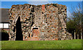
Castle Lug, Jordanstown/Greenisland
The remains of a tower house beside the Shore Road. Date of building unknown. The name comes from the Lugge family who were prominent in Carrickfergus in the 16th and 17th centuries.
Image: © Albert Bridge
Taken: 31 Mar 2011
0.05 miles
2
Castle Lug, Jordanstown/Greenisland (2)
Castle Lug (Image – March 2011) with the existing single-carriageway Shore Road in the foreground. Acquisition of residential property, along the route, is far from complete. Many houses are still occupied.
Image: © Albert Bridge
Taken: 28 Feb 2012
0.06 miles
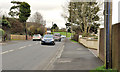
3
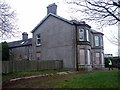
Abandoned House
As per details contained with this photo Image the A2 upgrade has begun and the houses due for demolition are now on borrowed time.
Image: © Chris Johnston
Taken: 4 Mar 2013
0.06 miles
4
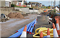
Road construction, Jordanstown/Greenisland (4)
The Shore Road under reconstruction, looking towards Carrickfergus, between Castle Lug and Shorelands.
Image: © Albert Bridge
Taken: 1 Dec 2013
0.06 miles
5
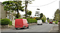
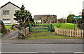
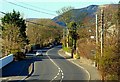
The Shore Road, Greenisland (3)
The Shore Road, past Neill’s Lane, looking towards Greenisland and Carrickfergus. Most of the houses are still occupied but will, eventually, be demolished to make way for the new road. Shorelands is in the background, at the white sign on the left.
Image: © Albert Bridge
Taken: 2 May 2012
0.07 miles
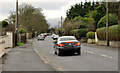
6
The Shore Road, Jordanstown/Greenisland (13)
The Shore Road, looking towards Carrickfergus, from slightly on the Greenisland side of Image The entrance to Shorelands is marked by the green hump of reserved line in the middle background.
Image: © Albert Bridge
Taken: 28 Feb 2012
0.07 miles
7
The Shore Road, Jordanstown/Greenisland (15)
The Shore Road, looking towards Carrickfergus, from opposite Castle Lug Image The entrance to Shorelands is at the green hump of reserved line (middle background).
Image: © Albert Bridge
Taken: 28 Feb 2012
0.08 miles
8
The Shore Road, Jordanstown/Greenisland (14)
The Shore Road, looking towards Belfast, from opposite Castle Lug Image This stretch has an abundance of trees and hedges which will have to go to make way for the new road.
Image: © Albert Bridge
Taken: 28 Feb 2012
0.08 miles
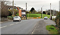
9
Shorelands, Greenisland (6)
The Shorelands development seen from the Shore Road. The reserved line is at middle left.
Image: © Albert Bridge
Taken: 2 May 2012
0.08 miles
10
The Shore Road near Jordanstown
See Image The road, to the NE of the previous photo, looking towards Belfast. This section of the road is to be dualled and will include a roundabout where I am standing. The land for it was reserved many years ago.
Image: © Albert Bridge
Taken: 22 Mar 2008
0.08 miles