IMAGES TAKEN NEAR TO
Shore Road, CARRICKFERGUS, BT38 8TT
Introduction
This page details the photographs taken nearby to Shore Road, BT38 8TT by members of the Geograph project.
The Geograph project started in 2005 with the aim of publishing, organising and preserving representative images for every square kilometre of Great Britain, Ireland and the Isle of Man.

There are currently over 7.5m images from over14,400 individuals and you can help contribute to the project by visiting https://www.geograph.org.uk
Image Map
Images are licensed for reuse under creativecommons.org/licenses/by-sa/2.0
Notes
- Clicking on the map will re-center to the selected point.
- The higher the marker number, the further away the image location is from the centre of the postcode.
Image Listing (22 Images Found)
Images are licensed for reuse under creativecommons.org/licenses/by-sa/2.0
Image
Details
Distance
1
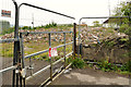
Rubble, Greenisland
A pile of rubble (part of which can be seen (foreground) in Image) from buildings demolished to make way for the proposed new dual carriageway. This section of the proposed road, between the Station Road and Seapark, is due to run off-line on the north western side of the existing Shore Road.
Image: © Albert Bridge
Taken: 2 May 2012
0.04 miles
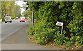
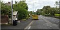
2
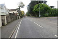
Shore Road
Section of the once busy Shore Road which has been by-passed by the now completed A2 dual carriageway, leaving it in peaceful isolation.
Image: © Robert Ashby
Taken: 28 Oct 2015
0.04 miles
3
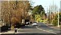
The Shore Road near Greenisland (1)
See Image The road, in this square, looking towards Belfast. This section is expected to be bypassed by the new road.
Image: © Albert Bridge
Taken: 22 Mar 2008
0.05 miles
4
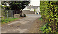
Lane, Greenisland (1)
A disused lane (now blocked by a fence) leading from Image, Image and Image to the Shore Road (background). This section of the proposed road, between the Station Road and Seapark, is due to run off-line on the north western side of the existing Shore Road. The usual practice would be for it to be stopped-up when the road is built.
Image: © Albert Bridge
Taken: 2 May 2012
0.05 miles
5
Lane, Greenisland (2)
This lane Image (bottom) joining the Shore Road (looking towards Belfast). To the best of my knowledge this stretch of the Shore Road is not directly affected by the proposed dual carriageway.
Image: © Albert Bridge
Taken: 2 May 2012
0.05 miles
6
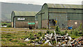
Vacant warehouses, Greenisland
Now vacant warehouses, off the Shore Road, which will be demolished to make way for the proposed new dual carriageway. This section of the proposed road, between the Station Road and Seapark, is due to run off-line on the north western side of the existing Shore Road. Well hidden, they are not visible from the road.
Image: © Albert Bridge
Taken: 2 May 2012
0.05 miles
7
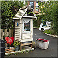
Community Library, Greenisland
A little community library on the Shore Road, Greenisland.
Image: © Rossographer
Taken: 27 Aug 2024
0.06 miles
8
Vacant ground, Greenisland
Part of a former commercial site, now cleared to make way for the proposed new dual carriageway. This section of the proposed road, between the Station Road and Seapark, is due to run off-line on the north western side of the existing Shore Road.
Image: © Albert Bridge
Taken: 2 May 2012
0.06 miles
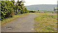
9
The Shore Road at Greenisland
The old A2, now relegated to just the Shore Road by the new bypass, though virtually traffic-free.
Image: © Rossographer
Taken: 27 Aug 2024
0.09 miles
10
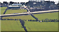
New dual carriageway, Greenisland (March 2015)
The off-line section of the new Jordanstown – Greenisland dual carriageway. This part seems to be ready to use but won’t be open to traffic until the connection to the existing dual carriageway, on the Trooperslane side, is complete. The view is from Knockagh Monument with the Shore Road in the background.
Image: © Albert Bridge
Taken: 21 Mar 2015
0.10 miles