IMAGES TAKEN NEAR TO
Belfast Road, CARRICKFERGUS, BT38 8PE
Introduction
This page details the photographs taken nearby to Belfast Road, BT38 8PE by members of the Geograph project.
The Geograph project started in 2005 with the aim of publishing, organising and preserving representative images for every square kilometre of Great Britain, Ireland and the Isle of Man.

There are currently over 7.5m images from over14,400 individuals and you can help contribute to the project by visiting https://www.geograph.org.uk
Image Map
Images are licensed for reuse under creativecommons.org/licenses/by-sa/2.0
Notes
- Clicking on the map will re-center to the selected point.
- The higher the marker number, the further away the image location is from the centre of the postcode.
Image Listing (22 Images Found)
Images are licensed for reuse under creativecommons.org/licenses/by-sa/2.0
Image
Details
Distance
1
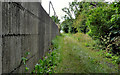
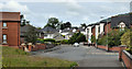
Lane, Carrickfergus
The Belfast Road end of a lane which formerly led to and through part of the old Courtaulds factory Image (behind the wall on the left). I might be wrong but I think that it eventually led to the railway close to Mount station. The station was built to serve employees of the factory and did not have any public access.
Image: © Albert Bridge
Taken: 1 Jul 2011
0.02 miles
2
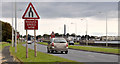
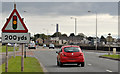
"End of dual carriageway" sign, Trooperslane, Carrickfergus
The “end of dual carriageway” sign at the end of this short stretch (about a mile) of dual carriageway on the Belfast – Carrickfergus road. It continues as a four-lane road as far as Downshire.
Image: © Albert Bridge
Taken: 1 Jul 2011
0.03 miles
3
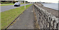
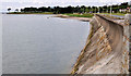
The seawall near Carrickfergus (1)
Part of the seawall, on the Belfast side of the Sloefield Road. Now some 40 years old and well plastered, there are no cracks to allow the accumulation of wind-blown soil and no wildflowers.
Image: © Albert Bridge
Taken: 1 Jul 2011
0.06 miles
4
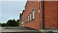
Former Courtaulds factory, Carrickfergus (2)
See Image A remaining part of the former Courtaulds factory – facing the Belfast Road.
Image: © Albert Bridge
Taken: 1 Jul 2011
0.07 miles
5
"Traffic signals ahead" sign, Carrickfergus
Sign, on the Belfast Road, for outward traffic approaching the Sloefield Road Image For the benefit of anyone seeing this photograph from outside the EU, triangular signs are warning signs. Circular ones are compulsory, for example, speed limits Image
Image: © Albert Bridge
Taken: 1 Jul 2011
0.08 miles
6
The seawall, Carrickfergus (2)
The seawall, between Carrickfergus and Trooperslane, with Seapark in the background.
Image: © Albert Bridge
Taken: 1 Jul 2011
0.08 miles
7
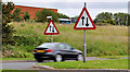
"Two-way traffic ahead" signs, Carrickfergus
Signs, near the end of this section of dual carriageway Image, warning of two-way traffic on the approaching four-lane section.
Image: © Albert Bridge
Taken: 1 Jul 2011
0.08 miles
8
The Old Shore Road, Trooperslane, Carrickfergus
Part of the Shore Road long-since replaced by a dual carriageway Image on the seaward side. Most of the houses post-date the dual carriageway.
Image: © Albert Bridge
Taken: 1 Jul 2011
0.08 miles
9
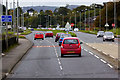
Belfast Road, Start of Double Carriageway Section near Carrickfergus
Image: © David Dixon
Taken: 28 Sep 2017
0.09 miles
10
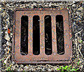
PAM grating cover, Carrickfergus
A grating cover, at the bus stop lay-by, on the Belfast Road, bearing the PAM Image logo (top left).
Image: © Albert Bridge
Taken: 1 Jul 2011
0.09 miles