IMAGES TAKEN NEAR TO
Windmill Avenue, CARRICKFERGUS, BT38 8DH
Introduction
This page details the photographs taken nearby to Windmill Avenue, BT38 8DH by members of the Geograph project.
The Geograph project started in 2005 with the aim of publishing, organising and preserving representative images for every square kilometre of Great Britain, Ireland and the Isle of Man.

There are currently over 7.5m images from over14,400 individuals and you can help contribute to the project by visiting https://www.geograph.org.uk
Image Map
Images are licensed for reuse under creativecommons.org/licenses/by-sa/2.0
Notes
- Clicking on the map will re-center to the selected point.
- The higher the marker number, the further away the image location is from the centre of the postcode.
Image Listing (46 Images Found)
Images are licensed for reuse under creativecommons.org/licenses/by-sa/2.0
Image
Details
Distance
1
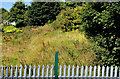
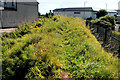
Former harbour railway, Carrickfergus (2)
See Image Standing on the embankment in the previous photo and looking (northwest) at the remaining section of the former harbour branch. Continue to Image
Image: © Albert Bridge
Taken: 2 Sep 2010
0.13 miles
2
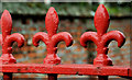
Gate detail, Carrickfergus
Extensive use of the fleur-de-lys http://en.wikipedia.org/wiki/Fleur-de-lis on a fence and gate, along the Belfast Road, opposite Windmill Avenue.
Image: © Albert Bridge
Taken: 5 Feb 2011
0.13 miles
3
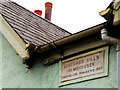
Gill's Almshouses, Carrickfergus (3)
See Image The plaque recording the building and renovation dates as 1761 and 1904 respectively. Subsequent research by architectural historians shows that the row is not the original almshouses. They were replaced by the present buildings in 1820. There was a second renovation in 1980.
Image: © Albert Bridge
Taken: 5 Feb 2011
0.15 miles
4
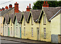
Gill's Almshouses, Carrickfergus (2)
See Image The other Gill’s Almshouses - in Ellis Street. For more about the date of building see Image
Image: © Albert Bridge
Taken: 5 Feb 2011
0.15 miles
5
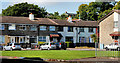
Davys Street, Carrickfergus
Sometimes spelled “Davy’s” as if there had once been a man of that Christian name. Without the apostrophe it might refer to a local family, in the Victorian era, with the surname “Davys”. The houses in the photo are around a square off the street but have the postal address of Davys Street.
Image: © Albert Bridge
Taken: 2 Sep 2010
0.16 miles
6
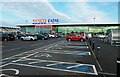
Tesco Extra, Minorca Place, Carrickfergus, N. Ireland
Large supermarket with cafe upstairs. There is also a fuel station on the site.
Image: © P L Chadwick
Taken: 6 Oct 2021
0.16 miles
7
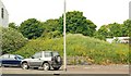
Former harbour railway, Carrickfergus
The branch to Carrickfergus harbour left the Belfast – Larne line by a facing junction ten chains on the Belfast side of Clipperstown station Image It opened in 1887 and closed in 1957. The trackbed survived for more than 30 years before falling to development. This short stretch of embankment, beside the Belfast Road, still survives. Continue to Image Image shows a similar view after removal of the remains of the embankment.
Image: © Albert Bridge
Taken: 12 Jun 2009
0.16 miles
8
Former harbour railway, Carrickfergus (3)
See Image The view in the other direction – towards the harbour.
Image: © Albert Bridge
Taken: 2 Sep 2010
0.16 miles
9
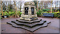
Legg Park, Carrickfergus
Legg Park is a small park between the Belfast Road and the redeveloped land close to the harbour. This memorial commemorates 2nd Lt Charles Legg after whom it is named. See also Image
Image: © Albert Bridge
Taken: 5 Feb 2011
0.16 miles
10
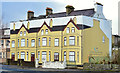
Derelict houses, Belfast Road, Carrickfergus (April 2015)
See Image (September 2010). Still derelict, still standing but now hidden by a disguise.
Image: © Albert Bridge
Taken: 3 Apr 2015
0.16 miles