IMAGES TAKEN NEAR TO
Harmin Park, NEWTOWNABBEY, BT36 7UT
Introduction
This page details the photographs taken nearby to Harmin Park, BT36 7UT by members of the Geograph project.
The Geograph project started in 2005 with the aim of publishing, organising and preserving representative images for every square kilometre of Great Britain, Ireland and the Isle of Man.

There are currently over 7.5m images from over14,400 individuals and you can help contribute to the project by visiting https://www.geograph.org.uk
Image Map
Images are licensed for reuse under creativecommons.org/licenses/by-sa/2.0
Notes
- Clicking on the map will re-center to the selected point.
- The higher the marker number, the further away the image location is from the centre of the postcode.
Image Listing (14 Images Found)
Images are licensed for reuse under creativecommons.org/licenses/by-sa/2.0
Image
Details
Distance
1
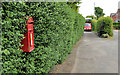
Letter box, Glengormley
Post-mounted EIIR letter box (BT36 622) at Moyola Park on the Antrim Road.
Image: © Albert Bridge
Taken: 29 May 2012
0.11 miles
2
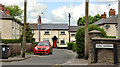
Rural Gardens, Glengormley
A street, on the north western side of the Hightown Road, close to the M2 Image The 1966 one-inch map shows it at the limit of developed Greater Belfast. Shortly afterwards the Ministry of Commerce and the Antrim and Ballymena Development Commission began acquiring much of the land between the Hightown Road and Mallusk for industrial and commercial development. One of the attractions of the area was its proximity to the Sandyknowes roundabout Image The Hightown Road ceased to be rural.
Image: © Albert Bridge
Taken: 29 May 2012
0.17 miles
3
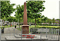
Glengormley war memorial (1)
Glengormley war memorial on the Ballyclare Road. Similar to the one at Whiteabbey Image Image shows the inscription.
Image: © Albert Bridge
Taken: 29 May 2012
0.17 miles
4
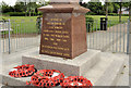
Glengormley war memorial (2)
See Image The inscription.
Image: © Albert Bridge
Taken: 29 May 2012
0.17 miles
5
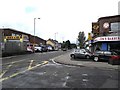
Ballyclare Road, Glengormley
At the junction with Portland Avenue.
Image: © Dean Molyneaux
Taken: 20 Aug 2009
0.17 miles
6
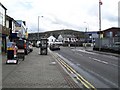
Junction of Antrim Road and Ballyclare Road, Glengormley
Left for Belfast, right for Antrim.
Image: © Dean Molyneaux
Taken: 20 Aug 2009
0.20 miles
7
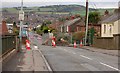
The Hightown Road, Glengormley
See Image The Hightown Road is currently closed to facilitate work on utilities etc http://www.northernireland.gov.uk/news/news-drd/news-drd-151007-hightown-bridge-closure.htm.
Image: © Albert Bridge
Taken: 27 Oct 2007
0.21 miles
8
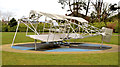
"Mayfly" aircraft sculpture, Glengormley
A sculpture, by Skelton Rainey, of the biplane “Mayfly” http://en.wikipedia.org/wiki/Bland_Mayfly , in Glengormley Park, Ballyclare Road, commemorating Lilian Bland http://www.newulsterbiography.co.uk/index.php/home/viewPerson/117, the first woman to design, build and fly her own aeroplane. See also Image
Image: © Albert Bridge
Taken: 24 Mar 2014
0.22 miles
9
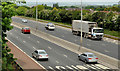
The M2 hill section, Glengormley
Image showed the M2 during the construction of a third (inward/southbound) lane in October 2007. Unfortunately the low bridge Image, on the Hightown Road has been replaced by something a bit higher, at chin level, making an exact “before and after” impossible. This view is from the Hightown Road but looking diagonally across the motorway. The lorry is on the “new” third lane. The old corrugated crash barrier has been replaced by the modern concrete variety.
Image: © Albert Bridge
Taken: 29 May 2012
0.22 miles
10
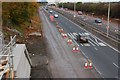
The M2 (northbound) at Glengormley
See Image The view outwards from the Hightown Road bridge near Glengormley. The abutment for the new bridge is at lower left. The inside lane is closed to traffic but in use by contractors’ vehicles. (The Google map shows this bridge as going under rather than over the motorway).
Image: © Albert Bridge
Taken: 27 Oct 2007
0.23 miles