IMAGES TAKEN NEAR TO
Sandyholme Park, NEWTOWNABBEY, BT36 5BJ
Introduction
This page details the photographs taken nearby to Sandyholme Park, BT36 5BJ by members of the Geograph project.
The Geograph project started in 2005 with the aim of publishing, organising and preserving representative images for every square kilometre of Great Britain, Ireland and the Isle of Man.

There are currently over 7.5m images from over14,400 individuals and you can help contribute to the project by visiting https://www.geograph.org.uk
Image Map
Images are licensed for reuse under creativecommons.org/licenses/by-sa/2.0
Notes
- Clicking on the map will re-center to the selected point.
- The higher the marker number, the further away the image location is from the centre of the postcode.
Image Listing (14 Images Found)
Images are licensed for reuse under creativecommons.org/licenses/by-sa/2.0
Image
Details
Distance
1
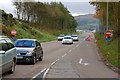
Sandyknowes roundabout near Belfast (3)
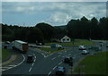
See Image The north-bound off-slip from the M2. This is controlled by lights.
Image: © Albert Bridge
Taken: 27 Oct 2007
0.12 miles
2
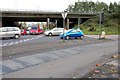
Sandyknowes roundabout near Belfast (4)
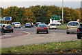
See Image The slip road to Scullions Road Image is in the foreground. The off-slip from the M2 Image is at middle right. The south-bound on-slip to Belfast is behind the flyover to the right. The full-time lights have made negotiation of the roundabout somewhat safer and less fraught.
Image: © Albert Bridge
Taken: 27 Oct 2007
0.13 miles
3
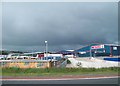
Henderson Food Services Depot at Newtownabbey
Henderson own the Spar and Vivo franchises for Northern Ireland. The depot stands next to the M2.
Image: © Eric Jones
Taken: 9 Aug 2011
0.15 miles
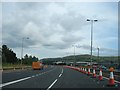
4
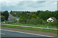
The A8(M)
The road to Larne, viewed from the M2 motorway at Sandyknowes Roundabout.
Image: © Thomas Nugent
Taken: 1 Jun 2019
0.18 miles
5
Sandyknowes roundabout near Belfast (1)
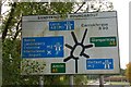
Sandyknowes roundabout is a celebrity roundabout and star of a thousand traffic reports on BBC Radio Ulster. The sign is self-explanatory. It is on Scullions Road which serves a large commercial area at Mallusk to the NW of Belfast. The roundabout now has full-time lights at some roads. There are vague plans for a flyover to connect it to the Larne road (A8 (M)).
Image: © Albert Bridge
Taken: 27 Oct 2007
0.19 miles
6
Sandyknowes roundabout near Belfast (2)
See Image Scullions Road is in the foreground (lower left). The road to Antrim is at middle-left. The traffic is heading for who-knowes-where!
Image: © Albert Bridge
Taken: 27 Oct 2007
0.19 miles
8
The Antrim Road near Glengormley
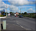
The A6 Antrim Road close to Sandyknowes roundabout. The Swanston Road is on the left.
Image: © Rossographer
Taken: 28 Jun 2011
0.21 miles
9
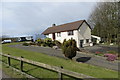
Location, location?
I don't know when this house was built - it looks fairly modern - but it must have been sometime in the pre motorway era i.e mid-sixties when construction of the M2 was started. Junction 4 (Sandyknowes) at this location was opened in 1975. With the nearby Sandyknowes roundabout, the M2, and the A26 at one end, the A8 (semi) motorway to Corr's Corner and Larne going past their back door and the busy B90 carrying lots of local traffic to the M2 passing their front garden who would buy a house in this location today?
Image: © Robert Ashby
Taken: 1 Apr 2015
0.21 miles
10
Slip Road at Junction 4 of the M2
The Fire Engine is not as it appears. You can rent it out for parties.
Image: © Ian Paterson
Taken: 24 Jul 2007
0.21 miles