IMAGES TAKEN NEAR TO
Downshire Road, NEWRY, BT34 1DX
Introduction
This page details the photographs taken nearby to Downshire Road, BT34 1DX by members of the Geograph project.
The Geograph project started in 2005 with the aim of publishing, organising and preserving representative images for every square kilometre of Great Britain, Ireland and the Isle of Man.

There are currently over 7.5m images from over14,400 individuals and you can help contribute to the project by visiting https://www.geograph.org.uk
Image Map
Images are licensed for reuse under creativecommons.org/licenses/by-sa/2.0
Notes
- Clicking on the map will re-center to the selected point.
- The higher the marker number, the further away the image location is from the centre of the postcode.
Image Listing (368 Images Found)
Images are licensed for reuse under creativecommons.org/licenses/by-sa/2.0
Image
Details
Distance
1
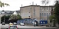
The Newry BT telephone exchange in Downshire Road
Image: © Eric Jones
Taken: 7 Apr 2012
0.01 miles
2

Newry Telephone Exchange viewed across the Newry Canal
Image: © Eric Jones
Taken: 9 May 2016
0.01 miles
3
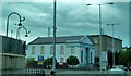
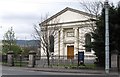
The bomb damaged Downshire Presbyterian Church
A car bomb aimed at the court house (on the left) caused much damage to the chapel.
Image: © Eric Jones
Taken: 2 Jul 2010
0.01 miles
4
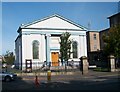
The Downshire Road Presbyterian Church
This main stream Presbyterian Church is situated on the junction of Downshire Road and New Street. The chapel dates from 1843. The building to the right is the Newry Telephone Exchange.
http://www.presbyterianireland.org/congregations/newrydownshire.html
Image: © Eric Jones
Taken: 22 Aug 2009
0.02 miles
5
Downshire Presbyterian Church, Newry
This main stream Presbyterian Church is situated on the junction of Downshire Road and New Street. The church dates from 1843. The building to the right is the Newry Telephone Exchange. http://www.presbyterianireland.org/congregations/newrydownshire.html
Image: © Eric Jones
Taken: 21 Jun 2018
0.02 miles
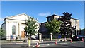
6
The Downshire Presbyterian Church, Newry
This is situated on the corner of Downshire Road and New Street, and with, unfortunately for it, Newry Courthouse as a neighbour.
http://www.belfasttelegraph.co.uk/news/local-national/northern-ireland/newry-congregation--lsquooverjoyedrsquo-as-bombed-church-rises-again-15091106.html
Image: © Eric Jones
Taken: 7 Apr 2012
0.03 miles
7
The rear of Downshire Road Presbyterian Church, Newry
This church stand across the road from Newry Courthouse, the target of a number of republican car bombings - the bollards on the right have been added in an attempt to further protect the well defended courthouse. The church - minus blast walls and bollards - has suffered more damage from these attacks than the intended target. On the night of February 22nd, 2010, damage estimated at £350,000 was caused to the church when a dissidents' device exploded outside the Courthouse.
http://www.belfasttelegraph.co.uk/news/local-national/northern-ireland/newry-congregation-overjoyed-as-bombed-church-rises-again-28590748.html
http://en.wikipedia.org/wiki/Newry_car_bombing
Image: © Eric Jones
Taken: 31 Dec 2010
0.03 miles
8
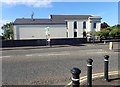
Side view of the Downshire Presbyterian Road, Newry
The image was taken from the A25. Located directly opposite Newry Courthouse, this church has been badly damaged on a number of occasions by explosive devices planted in the vicinity of the courthouse.
Image: © Eric Jones
Taken: 21 Jun 2018
0.03 miles
9
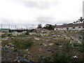
Waste ground next to the BT phone exchange in Downshire Road
Image: © Eric Jones
Taken: 7 Apr 2012
0.03 miles
10
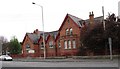
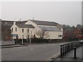
The Newry Teacher's Centre, Downshire Road
Image: © Eric Jones
Taken: 7 Apr 2012
0.03 miles