IMAGES TAKEN NEAR TO
Loughend Road, BANBRIDGE, BT32 3NP
Introduction
This page details the photographs taken nearby to Loughend Road, BT32 3NP by members of the Geograph project.
The Geograph project started in 2005 with the aim of publishing, organising and preserving representative images for every square kilometre of Great Britain, Ireland and the Isle of Man.

There are currently over 7.5m images from over14,400 individuals and you can help contribute to the project by visiting https://www.geograph.org.uk
Image Map
Images are licensed for reuse under creativecommons.org/licenses/by-sa/2.0
Notes
- Clicking on the map will re-center to the selected point.
- The higher the marker number, the further away the image location is from the centre of the postcode.
Image Listing (15 Images Found)
Images are licensed for reuse under creativecommons.org/licenses/by-sa/2.0
Image
Details
Distance
1
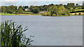
Loughbrickland lake (4)
Park of Loughbrickland lake seen from a recently-opened path along the western shore. There is also an area of reedmace, part of which can be seen at bottom left.
Image: © Albert Bridge
Taken: 19 Sep 2012
0.14 miles
2
The Old Dublin Road near Loughbrickland
The former (single-carriageway) Dublin Road (bottom), now an unclassified road with picnic tables Image, seen from the dual carriageway Image
Image: © Albert Bridge
Taken: 19 May 2012
0.16 miles
3
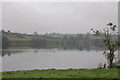
Loughbrickland lake (1)
Loughbrickland lake is one of the main features visible from the Belfast-Newry/Dublin road. It includes a crannog and is covered by three squares. This is the section of the lake in J1140 seen on a misty autumn day. The Belfast-Dublin road is just about visible in the middle right of the photo.
Image: © Albert Bridge
Taken: 20 Oct 2006
0.16 miles
4
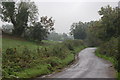
The Lough End Road, Loughbrickland
See Image The Lough End Road skirts part of the eastern shore of the lake. This is the view towards Newry with the lake out of sight behind the trees on the right.
Image: © Albert Bridge
Taken: 20 Oct 2006
0.16 miles
5
By Loughbrickland lake (2)
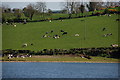
A herd of (mainly) friesians grazing, in the sun, by the SE shore of Loughbrickland lake.
Image: © Albert Bridge
Taken: 27 Apr 2007
0.16 miles
6
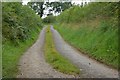
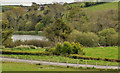
The Brickland Road near Loughbrickland (1)
The Brickland Road is a minor road to the SE of Loughbrickland. It runs roughly parallel to the Belfast – Dublin dual carriageway and carries a lot less traffic!!
Image: © Albert Bridge
Taken: 31 Aug 2007
0.16 miles
7
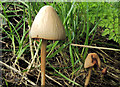
Fungus near Loughbrickland
A fungus, growing in a grassy verge, at the lay-by here Image
Image: © Albert Bridge
Taken: 29 Sep 2012
0.18 miles
8
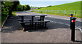
Picnic site near Loughbrickland
Part of the loop of the old road has now been converted into a picnic site. The present road lies behind the cutting (right) which makes quite an effective sound barrier.
Image: © Albert Bridge
Taken: 31 May 2010
0.20 miles
9
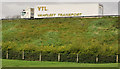
Road embankment near Loughbrickland
Shortly after passing Loughbrickland lake Image the Belfast – Dublin road Image is carried on this embankment on the western side of the old single-carriageway road (behind me), now an unclassified road with a picnic tables Image The Google map uses blue to show the road although it’s not a motorway.
Image: © Albert Bridge
Taken: 19 May 2012
0.20 miles
10
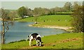
At pasture, Loughbrickland
Dairy cattle at pasture by the eastern side of Loughbrickland lake.
Image: © Albert Bridge
Taken: 7 May 2008
0.21 miles