IMAGES TAKEN NEAR TO
Nevins Row, LISBURN, BT27 5TF
Introduction
This page details the photographs taken nearby to Nevins Row, BT27 5TF by members of the Geograph project.
The Geograph project started in 2005 with the aim of publishing, organising and preserving representative images for every square kilometre of Great Britain, Ireland and the Isle of Man.

There are currently over 7.5m images from over14,400 individuals and you can help contribute to the project by visiting https://www.geograph.org.uk
Image Map
Images are licensed for reuse under creativecommons.org/licenses/by-sa/2.0
Notes
- Clicking on the map will re-center to the selected point.
- The higher the marker number, the further away the image location is from the centre of the postcode.
Image Listing (40 Images Found)
Images are licensed for reuse under creativecommons.org/licenses/by-sa/2.0
Image
Details
Distance
1
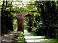
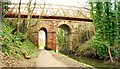
Ballyskeagh Bridge
Built c 1760 of local sandstone the bridge carries the Drumbeg to Lambeg road high above the now disused Lagan Canal.
Image: © Robert Ashby
Taken: 30 Aug 2010
0.03 miles
2
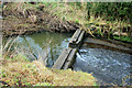
Ballyskeagh lock, disused Lagan canal
The Lisburn end of the disused no 8 (Ballyskeagh) lock.
Image: © Albert Bridge
Taken: 22 Feb 2010
0.04 miles
3
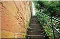
The Ballyskeagh High Bridge (6 of 8)
See Image These closed and fenced steps led from the towpath to the Ballyskeagh Road. The present pedestrian route is via the towpath to McIlroy Park and the road. Continue to Image
Image: © Albert Bridge
Taken: 26 Feb 2009
0.04 miles
4
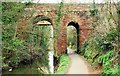
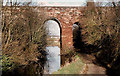
The Ballyskeagh High Bridge (1 of 8)
Image gives the building date. The two-arch bridge crosses the Lagan Navigation (left) and the towpath (right). The road (now called the Ballyskeagh Road) is much higher than the canal – an interesting challenge for a civil engineer 250 years ago. The view is towards Belfast. The towpath here is narrower than elsewhere on the surviving stretches of disused canal. Continue to Image
Image: © Albert Bridge
Taken: 26 Feb 2009
0.05 miles
5
The Ballyskeagh High Bridge (4 of 8)
See Image Bearing in mind that the bridge was designed in the era of the horse, cart and stagecoach, it is still sufficiently wide to allow modern motor vehicles to cross (with care). Continue to Image
Image: © Albert Bridge
Taken: 26 Feb 2009
0.05 miles
6
The Ballyskeagh High Bridge (2 of 8)
See Image The view towards Lisburn with the disused navigation on the right and the narrowing towpath on the left. The footbridge, crossing both is at the top. Continue to Image
Image: © Albert Bridge
Taken: 26 Feb 2009
0.05 miles
7
The Ballyskeagh High Bridge, Drumbeg/Lambeg (12)
The Ballyskeagh High Bridge, looking towards Belfast. The only significant difference, after 27 years Image, is that the towpath has been re-surfaced and the trees have grown sufficiently to hide the Seymour Hill estate (background).
Image: © Albert Bridge
Taken: 6 Feb 1982
0.05 miles
8
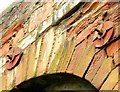
The Ballyskeagh High Bridge (8 of 8)
See Image The High Bridge has been strengthened at some time. I welcome any information about when. To go back to the start see Image
Image: © Albert Bridge
Taken: 26 Feb 2009
0.05 miles
9
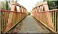
The Ballyskeagh High Bridge (5 of 8)
See Image This footbridge (on the northern side) allows pedestrians and cyclists to avoid the narrow road bridge. The view is towards Lisburn. Continue to Image
Image: © Albert Bridge
Taken: 26 Feb 2009
0.05 miles
10
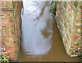
The Lagan canal, Ballyskeagh (November 2014)
The view from this footbridge Image showing the full, muddy and disused Lagan canal as it passes under the Ballyskeagh High Bridge on the Ballyskeagh Road. Image (February 2009) shows the canal at a much lower level.
Image: © Albert Bridge
Taken: 15 Nov 2014
0.05 miles