IMAGES TAKEN NEAR TO
Portaferry Road, NEWTOWNARDS, BT23 8SN
Introduction
This page details the photographs taken nearby to Portaferry Road, BT23 8SN by members of the Geograph project.
The Geograph project started in 2005 with the aim of publishing, organising and preserving representative images for every square kilometre of Great Britain, Ireland and the Isle of Man.

There are currently over 7.5m images from over14,400 individuals and you can help contribute to the project by visiting https://www.geograph.org.uk
Image Map
Images are licensed for reuse under creativecommons.org/licenses/by-sa/2.0
Notes
- Clicking on the map will re-center to the selected point.
- The higher the marker number, the further away the image location is from the centre of the postcode.
Image Listing (13 Images Found)
Images are licensed for reuse under creativecommons.org/licenses/by-sa/2.0
Image
Details
Distance
1
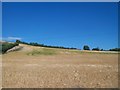
Cereal crop on drumlin above the Portaferry Road
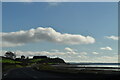
Here the Portaferry Road runs along the shore of Strangford Lough.
Image: © Eric Jones
Taken: 2 Aug 2013
0.12 miles
2
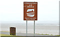
Brown sign, Ballyreagh, Newtownards (February 2015)
A brown sign “Strangford and Lecale Area of Outstanding Natural Beauty”, at the Ballyreagh layby, between the Portaferry Road and Strangford Lough.
Image: © Albert Bridge
Taken: 12 Feb 2015
0.12 miles
3
The Portaferry Road, Newtownards (2013-2)
A twisting section of the Portaferry Road, south of The Maltings Image, as it runs very close to the shore of Strangford Lough (left). This view is towards Newtownards.
Image: © Albert Bridge
Taken: 10 Apr 2013
0.12 miles
5
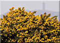
Whins, Ballyreagh, Newtownards
Flowering whin bushes between the Portaferry Road and the shore of Strangford Lough.
Image: © Albert Bridge
Taken: 10 Apr 2013
0.13 miles
6
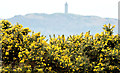
Whins, Ballyreagh, Newtownards (February 2015)
Whin bushes, showing their first real colour in 2015, bedside the Portaferry Road. Image shows another part of the same growth in April 2013.
Image: © Albert Bridge
Taken: 12 Feb 2015
0.13 miles
7
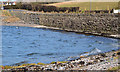
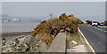
The seawall, Ballyreagh near Newtownards
There are several places, along the eastern shore of Strangford Lough, where the Portaferry – Newtownards road runs very close to the sea. In this case the seawall also seems to act as a retaining wall for the road.
Image: © Albert Bridge
Taken: 28 Feb 2014
0.14 miles
8
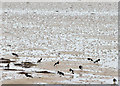
Oystercatchers, Strangford Lough, Newtownards (February 2015)
Oystercatchers feeding on the inter-tidal mud of Strangford Lough, about 1¼ hours before low water Killyleagh.
Image: © Albert Bridge
Taken: 12 Feb 2015
0.16 miles
10
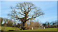
Tree and field gate near Newtownards
A field gate, beside a leafless winter tree, on the northern side of the Portaferry Road.
Image: © Albert Bridge
Taken: 28 Feb 2014
0.20 miles