IMAGES TAKEN NEAR TO
Dickson Park, NEWTOWNARDS, BT23 6JD
Introduction
This page details the photographs taken nearby to Dickson Park, BT23 6JD by members of the Geograph project.
The Geograph project started in 2005 with the aim of publishing, organising and preserving representative images for every square kilometre of Great Britain, Ireland and the Isle of Man.

There are currently over 7.5m images from over14,400 individuals and you can help contribute to the project by visiting https://www.geograph.org.uk
Image Map
Images are licensed for reuse under creativecommons.org/licenses/by-sa/2.0
Notes
- Clicking on the map will re-center to the selected point.
- The higher the marker number, the further away the image location is from the centre of the postcode.
Image Listing (20 Images Found)
Images are licensed for reuse under creativecommons.org/licenses/by-sa/2.0
Image
Details
Distance
1
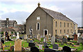
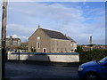
Trinity Presbyterian church, Ballygowan
Presbyterian church, at the Church Hill, with a datestone reading “1838”’. Listed as HB24/16/001 where the description includes “Large, relatively plain, two storey gabled Presbyterian church of 1838”. Architect not recorded. There is a later extension at the back. Last seen in December 2007 Image The former orphanage Image, on the Comber Road, is at middle left.
Image: © Albert Bridge
Taken: 21 Jan 2012
0.06 miles
2
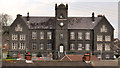
Former orphanage, Ballygowan (3)
In a village without a church spire, the former orphanage is the dominant feature. This view, across the rooftops, is from the Church Hill.
Image: © Albert Bridge
Taken: 21 Jan 2012
0.07 miles
3
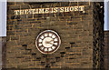
Former orphanage, Ballygowan (2)
The clock tower with clock (not working) and the inscription “THE TIME IS SHORT”.
Image: © Albert Bridge
Taken: 21 Jan 2012
0.07 miles
4
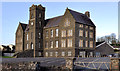
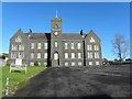
Former orphanage, Ballygowan (1)
The building seen from the Comber Road.
Image: © Albert Bridge
Taken: 21 Jan 2012
0.07 miles
5
Church building, Ballygowan
Pictured along Comber Road
Image: © Kenneth Allen
Taken: 19 Oct 2011
0.08 miles
6
Trinity Presbyterian Church in Ballygowan
Image: © Ken Crockard
Taken: 9 Dec 2007
0.08 miles
7
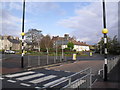
Roundabout in Ballygowan
The focal point of the village where traffic is concerned.
Image: © Dean Molyneaux
Taken: 25 Oct 2009
0.09 miles
8
Roundabout sign, Ballygowan (February 2015)
Cast your mind back to those geography lessons when you were told that a crossroads was one of the reasons why a town developed on a particular site. Banbridge and Ballygowan have always struck me as being the two classic examples in Co Down. The main road here was from Bangor, Newtownards and Comber to the county town at Downpatrick (via Saintfield). The flow of traffic over the crossroads is now controlled by a roundabout. The sign has a white background indicating that the roads, although classified “A”, are not primary ones. See also Image (October 2009).
Image: © Albert Bridge
Taken: 9 Feb 2015
0.11 miles
9
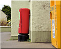
Pillar box, Ballygowan
EIIR pillar box (and recycling bin) outside the post office on the Saintfield Road.
Image: © Albert Bridge
Taken: 21 Jan 2012
0.14 miles
10
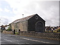
Former goods shed, Ballygowan
The goods shed at Ballygowan Station (closed 1950). Ballygowan was once a stop on the Belfast & County Down Railway from Belfast Queen's Quay to Newcastle.
Image: © Dean Molyneaux
Taken: 25 Oct 2009
0.14 miles