IMAGES TAKEN NEAR TO
Park Drive, BANGOR, BT20 4JZ
Introduction
This page details the photographs taken nearby to Park Drive, BT20 4JZ by members of the Geograph project.
The Geograph project started in 2005 with the aim of publishing, organising and preserving representative images for every square kilometre of Great Britain, Ireland and the Isle of Man.

There are currently over 7.5m images from over14,400 individuals and you can help contribute to the project by visiting https://www.geograph.org.uk
Image Map
Images are licensed for reuse under creativecommons.org/licenses/by-sa/2.0
Notes
- Clicking on the map will re-center to the selected point.
- The higher the marker number, the further away the image location is from the centre of the postcode.
Image Listing (502 Images Found)
Images are licensed for reuse under creativecommons.org/licenses/by-sa/2.0
Image
Details
Distance
1
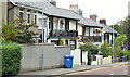
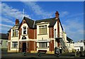
Park Drive, Bangor
A short street, between the Hamilton Road and Castle Street, laid out around 1920. Most of the houses in the photograph are said to date from about 1925 and feature balconies, verandahs and fancy cast ironwork.
Image: © Albert Bridge
Taken: 17 Sep 2013
0.02 miles
2
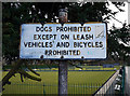
Sign, Ward Park
Ageing sign in Ward Park, Bangor - 'leash' is rarely used these days. The rules for dogs and bicycles are largely ignored. See also http://www.geograph.org.uk/search.php?i=10679719 for many related images of the same area.
Image: © Rossographer
Taken: 5 Feb 2010
0.02 miles
3
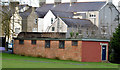
Former air raid shelter, Bangor
A former public air raid shelter, at the Park Drive end of Ward Park, described in http://ww2ni.webs.com/countydownpart4.htm and similar to the one in Lisburn Image The Luftwaffe bombed Bangor twice – on 13 September 1940 and 15/16 April 1941. Previously seen in Image (May 2010).
Image: © Albert Bridge
Taken: 8 Jan 2013
0.03 miles
4
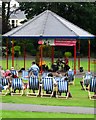
Concert, Ward Park, Bangor
A calypso band in concert at the bandstand in Ward Park.
Image: © Rossographer
Taken: 3 Aug 2008
0.03 miles
5
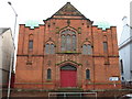
Dufferin Memorial Hall
The Dufferin Memorial Hall in Hamilton Road.
Image: © Sue Adair
Taken: 16 Aug 2008
0.03 miles
6
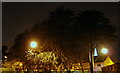
Edge of Ward Park by night
Looking from the park towards Park Drive with the town centre beyond.
Image: © Rossographer
Taken: 9 Dec 2007
0.03 miles
7
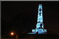
Bangor War Memorial, by night
The war memorial in Ward Park by night.
Image: © Rossographer
Taken: 9 Dec 2007
0.04 miles
8
Royal British Legion, Bangor
Royal British Legion, Bangor branch, located on Hamilton Road. The foundation stone for the club was laid by Maude, Lady Clanmorris, on the 17th January 1933 Image and it was opened by Viscount Bangor on the 1st July 1933 Image
Image: © Rossographer
Taken: 21 Sep 2008
0.05 miles
9
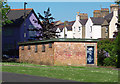
Cycling club, Bangor
This old brick building which sits on the edge of Ward Park beside Park Drive has, for many years, been home to North Down Cycling Club http://www.northdowncc.com/ . The building is a converted WW2 air raid shelter - see http://ww2ni.webs.com/countydownpart4.htm and Image
Image: © Rossographer
Taken: 23 May 2010
0.05 miles
10
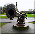
Big Gun, Ward Park
The gun taken from a World War One U-Boat in Ward Park, Bangor. See also Image, Image and Image for more information.
Image: © Rossographer
Taken: 1 Jan 2008
0.05 miles