IMAGES TAKEN NEAR TO
Maxwell Gardens, BANGOR, BT20 3LF
Introduction
This page details the photographs taken nearby to Maxwell Gardens, BT20 3LF by members of the Geograph project.
The Geograph project started in 2005 with the aim of publishing, organising and preserving representative images for every square kilometre of Great Britain, Ireland and the Isle of Man.

There are currently over 7.5m images from over14,400 individuals and you can help contribute to the project by visiting https://www.geograph.org.uk
Image Map
Images are licensed for reuse under creativecommons.org/licenses/by-sa/2.0
Notes
- Clicking on the map will re-center to the selected point.
- The higher the marker number, the further away the image location is from the centre of the postcode.
Image Listing (99 Images Found)
Images are licensed for reuse under creativecommons.org/licenses/by-sa/2.0
Image
Details
Distance
1
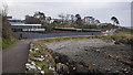
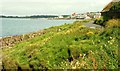
Path, Bangor
The North Down Coastal Path at Brompton, Bangor. The houses last seen in Image now look virtually complete. Taken during the Covid-19 pandemic, there were still a fair number of walkers out but most maintaining a distance from others.
Image: © Rossographer
Taken: 25 Mar 2020
0.05 miles
2
Manhole cover, Bangor
Manhole cover located on the North Down Coastal Path near Brompton Road in Bangor. No names or markings on this example, although it is clearly quite old.
Image: © Rossographer
Taken: 11 Jun 2011
0.05 miles
3
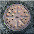
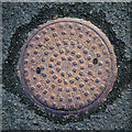
Manhole cover, Bangor
Manhole cover located on the North Down Coastal Path near Brompton Road in Bangor. It is marked "Adams" as well as "Patent Conical Cover". It is almost certainly from the firm Adams Hydraulics Ltd. I can't find too much out about Adams Limited, but they appear to have been involved in the water and sewage treatment industry and may still be trading as Ham Baker Adams / Adams Hydraulics - http://www.adamshydraulics.co.uk/ . Clarifications welcomed.
Image: © Rossographer
Taken: 11 Jun 2011
0.05 miles
4
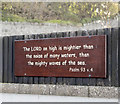
Religious message, Bangor
Bible quotation attached to a fence (facing the sea) at Brompton, Bangor.
Image: © Rossographer
Taken: 4 Nov 2016
0.06 miles
5

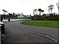
Construction site, Bangor
Construction site at the shoreline by Brompton in Bangor. Three modern dwellings are being constructed, replacing one bungalow. The walkers in the foreground are on the North Down Coastal Path heading towards Bangor.
Image: © Rossographer
Taken: 29 Apr 2019
0.06 miles
6
The North Down Coastal Path, Bangor
The North Down Coastal Path, looking towards Wilson’s Point, showing just how close it is to the sea.
Image: © Albert Bridge
Taken: 12 Aug 2008
0.06 miles
7
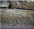
Bench Mark, Bangor
Cut bench mark at the foot of a wall in front of a house on the Maxwell Road in Bangor.
See also http://www.geograph.org.uk/search.php?i=11037856 for many other examples I have found.
Image: © Rossographer
Taken: 7 Mar 2010
0.06 miles
8
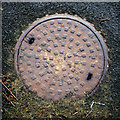
Manhole cover, Bangor
Manhole cover located on the North Down Coastal Path near Brompton Road in Bangor. It is marked "Adams Hydraulics - York London" as well as "Patent Conical Cover". I can't find too much out about Adams Limited, but they appear to have been involved in the water and sewage treatment industry and may still be trading as Ham Baker Adams / Adams Hydraulics - http://www.adamshydraulics.co.uk/ . Clarifications on the above welcomed.
Image: © Rossographer
Taken: 11 Jun 2011
0.07 miles
9
The seaward end of Brompton Road, Bangor
This image was taken from the coastal path.
Image: © Eric Jones
Taken: 20 May 2012
0.07 miles
10
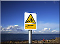
Warning sign, Bangor
Warning sign on the North Down Coastal Path on the western side of Bangor. One of dozens recently erected along the coastline of North Down warning of the dangers of waves and spray from the sea. Perhaps overkill on the part of the health and safety police, but then waves such as the one in Image seen a little further along the coast could prove deadly. An update of the older style of sign seen in Image
Image: © Rossographer
Taken: 20 Feb 2010
0.08 miles