IMAGES TAKEN NEAR TO
Craigleith Drive, BELFAST, BT16 2SA
Introduction
This page details the photographs taken nearby to Craigleith Drive, BT16 2SA by members of the Geograph project.
The Geograph project started in 2005 with the aim of publishing, organising and preserving representative images for every square kilometre of Great Britain, Ireland and the Isle of Man.

There are currently over 7.5m images from over14,400 individuals and you can help contribute to the project by visiting https://www.geograph.org.uk
Image Map
Images are licensed for reuse under creativecommons.org/licenses/by-sa/2.0
Notes
- Clicking on the map will re-center to the selected point.
- The higher the marker number, the further away the image location is from the centre of the postcode.
Image Listing (19 Images Found)
Images are licensed for reuse under creativecommons.org/licenses/by-sa/2.0
Image
Details
Distance
1
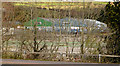
The Rolls-Royce site, Dundonald (2013-4)
The site seen through the leafless trees on the Upper Newtownards Road.
Image: © Albert Bridge
Taken: 18 Apr 2013
0.09 miles
2
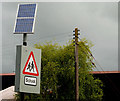
Solar panel. Dundonald
On the Upper Newtownards Road, near Ballyoran Lane, powering flashing lights on a “school” sign.
Image: © Albert Bridge
Taken: 16 May 2010
0.11 miles
3
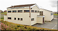
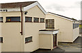
The Brooklands gospel centre, Dundonald (1)
A gospel centre, at Brooklands Crescent, which replaced a traditional wooden hut. The assembly was established, by the brethren in Dundonald gospel hall Image, to accommodate those who lived in the then-new Brooklands estate. The building opened (to the best of my knowledge) in 1972. This is the northern side. Image shows the western side.
Image: © Albert Bridge
Taken: 18 Apr 2013
0.12 miles
4
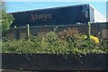
Adamsez Store on the Upper Newtownards Road
This store specializes in bathroom suites and showers.
Image: © Eric Jones
Taken: 21 May 2012
0.12 miles
5
The Brooklands gospel centre, Dundonald (2)
See Image The western side.
Image: © Albert Bridge
Taken: 18 Apr 2013
0.12 miles
6
Former "Adamsez", Dundonald
Now closed and vacant, the former Adamsez (NI) Ltd premises at the corner of the Upper Newtownards Road and Ballyoran Lane (foreground). The grid line cuts through the building.
Image: © Albert Bridge
Taken: 18 Apr 2013
0.12 miles
7
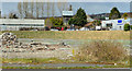
The Rolls-Royce site, Dundonald (2013-1)
Part of the site close to the northern side of the Upper Newtownards Road.
Image: © Albert Bridge
Taken: 18 Apr 2013
0.14 miles
8
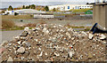
The Rolls-Royce site, Dundonald (2013-2)
A pile of rubble, inside the fence, close to the Carrowreagh Road.
Image: © Albert Bridge
Taken: 18 Apr 2013
0.14 miles
9
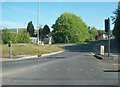
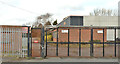
The entrance to Carrowreagh Road
This image was taken from the Upper Newtownards Road.
Image: © Eric Jones
Taken: 21 May 2012
0.14 miles
10
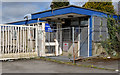
The Rolls-Royce site, Dundonald (2013-3)
The former security office, facing the Carrowreagh Road.
Image: © Albert Bridge
Taken: 18 Apr 2013
0.15 miles