IMAGES TAKEN NEAR TO
Quarry Cottages, BELFAST, BT16 2HQ
Introduction
This page details the photographs taken nearby to Quarry Cottages, BT16 2HQ by members of the Geograph project.
The Geograph project started in 2005 with the aim of publishing, organising and preserving representative images for every square kilometre of Great Britain, Ireland and the Isle of Man.

There are currently over 7.5m images from over14,400 individuals and you can help contribute to the project by visiting https://www.geograph.org.uk
Image Map
Images are licensed for reuse under creativecommons.org/licenses/by-sa/2.0
Notes
- Clicking on the map will re-center to the selected point.
- The higher the marker number, the further away the image location is from the centre of the postcode.
Image Listing (69 Images Found)
Images are licensed for reuse under creativecommons.org/licenses/by-sa/2.0
Image
Details
Distance
1
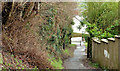
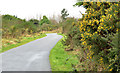
Lane, Dundonald
A short path running from Quarry Lane, across the Comber Greenway, to Grand Prix Park and the Comber Road.
Image: © Albert Bridge
Taken: 29 Jan 2014
0.04 miles
2
The Comber Greenway, Dundonald (2)
Image: © Albert Bridge
Taken: 23 Jan 2010
0.06 miles
3
Comber Greenway
Access point at Grand Prix Park leading to the Comber Road. Near Dundonald.
Image: © Robert Ashby
Taken: 22 Apr 2015
0.09 miles
4
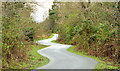
The Comber Greenway, Dundonald (8)
The Greenway, although built of the course of the old railway, does not quite run in a straight line. The path tends to avoid the damp ground – in this case through the use of a few squiggles. The view is back towards Grand Prix Park Image
Image: © Albert Bridge
Taken: 29 Jan 2014
0.10 miles
5
The Comber Greenway, Dundonald (7)
Much of the Greenway between the Eastlink Road and the Beersbridge Road is in deep cutting. This part, looking back to here Image, is in a shallow cutting behind Moatview Park. Some early whin flowers are now starting to appear.
Image: © Albert Bridge
Taken: 29 Jan 2014
0.11 miles
6
The Comber Greenway, Dundonald (9)
Further on towards the site of Dundonald station, looking back towards here Image, the path passes through an area where the south western side is particularly damp. The squiggles are more exaggerated than in the previous photograph.
Image: © Albert Bridge
Taken: 29 Jan 2014
0.16 miles
7
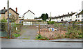
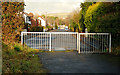
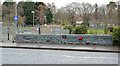
Vacant site, Dundonald
A cleared and vacant site at the corner of the Comber Road (foregroind) and Mawhinney Park.
Image: © Albert Bridge
Taken: 22 Nov 2012
0.16 miles
8
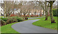
The Comber Greenway, Dundonald (6)
The Greenway, close to Moatview Park, looking down to the Eastlink Road and here Image This short stretch is one of the few parts not built on the course of the old railway.
Image: © Albert Bridge
Taken: 29 Jan 2014
0.17 miles
9
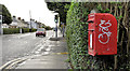
Letter box, Dundonald
Post-mounted EIIR letter box, on the Comber Road, at the corner of Grand Prix Park Image
Image: © Albert Bridge
Taken: 25 Nov 2011
0.17 miles
10
Bridge and culvert, Dundonald
The bridge carrying the Comber Road across this stream Image The section behind me is culverted back to the Eastlink Road.
Image: © Albert Bridge
Taken: 29 Jan 2014
0.18 miles